25 Fresnel Zones and Deployment
networking-core
net
prop
fresnel
25.1 Start With the Invisible Space Around the Link
A radio path is not only the straight line between antennas. The Fresnel zone is the surrounding space that must stay mostly clear if the receiver is going to see a stable signal.
That is why a link can look aligned and still fade when a roof edge, tree canopy, crop, vehicle, or hillside cuts into the zone. The practical story is to approve the whole path, not just the line of sight.
25.3 Learning Objectives
By the end of this chapter, you will be able to:
- Explain Fresnel zone requirements for reliable outdoor deployments
- Calculate first Fresnel zone radius for different frequencies and distances
- Apply the 60% clearance rule for reliable wireless links
- Design antenna heights for long-range deployments
- Troubleshoot ground-mounted sensor range issues
- Evaluate practical IoT deployments considering terrain and buildings
For Beginners: Fresnel Zones
When a wireless signal travels between two antennas, it does not just go in a straight line – it spreads out in an invisible football-shaped zone called a Fresnel zone. If trees, buildings, or hills poke into this zone, the signal gets weaker. Understanding Fresnel zones helps you position antennas so IoT devices can communicate reliably over long distances.
Invisible Fresnel Field
“My radio signal goes in a straight line to the gateway, right?” asked Sammy the Sensor. Max the Microcontroller shook his head. “Not exactly! Your signal actually spreads out in a big invisible football shape between you and the gateway. That shape is called the Fresnel zone.”
“A football shape?!” Lila the LED exclaimed. “So if a tree or a building pokes into that invisible football, my signal gets weaker?” Max nodded. “Exactly! You need at least 60% of that football zone to be clear of obstacles. That is why putting sensors on the ground is a bad idea – the Earth itself blocks the Fresnel zone!”
“Think of it like rolling a ball across a field,” said Bella the Battery. “If there are no bumps, it rolls smoothly. But if a hill sticks up in the middle, the ball gets deflected. For IoT antennas, the solution is simple – mount them higher up! The higher the antenna, the more of the Fresnel zone stays clear.”
“So when planning a LoRa network across a farm,” Sammy concluded, “we cannot just check that we can SEE the gateway. We need to make sure the whole invisible football between us is mostly clear of trees, hills, and buildings. That is why antenna height matters so much!”
25.4 Introduction
While path loss calculations assume a direct line-of-sight path between transmitter and receiver, wireless signals actually occupy a three-dimensional ellipsoid volume around this path called the Fresnel Zone. Understanding Fresnel zones is critical for outdoor IoT deployments, especially long-range links like LoRaWAN, Sigfox, and point-to-point Wi-Fi.
Chapter Roadmap
Use this chapter as a site-survey sequence:
- First define first-zone radius from distance and frequency.
- Then turn radius into height with the calculator, Wi-Fi example, and 5 km LoRa example.
- Next compare protocols, building penetration, and ground-sensor height.
- After that test the rule in examples, quizzes, and field records.
- Finally summarize the evidence package for installation and maintenance.
Checkpoints recap each decision. Collapsed notes, calculators, advanced examples, and quizzes deepen the same path.
25.5 What Are Fresnel Zones?
Fresnel zones are concentric ellipsoid regions around the direct line-of-sight path. Radio waves traveling through these zones can constructively or destructively interfere at the receiver depending on their path length.
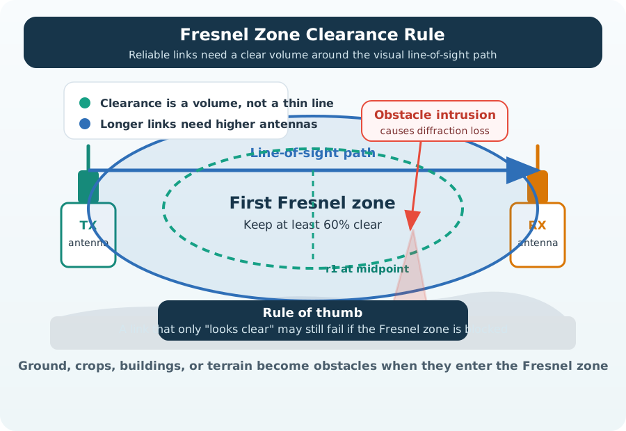
The diagram gives the shape. The next step is to put numbers on that shape so clearance becomes a design requirement instead of a sketch.
25.6 First Fresnel Zone Radius Formula
The radius of the first Fresnel zone at the midpoint between transmitter and receiver is:
\[r_1 = 17.3 \sqrt{\frac{d}{4f}}\]
Where:
- r_1 = First Fresnel zone radius (meters)
- d = Total distance between TX and RX (kilometers)
- f = Frequency (GHz)
Alternative Formula (for any point along the path):
\[r_1 = \sqrt{\frac{\lambda \, d_1 \, d_2}{d_1 + d_2}}\]
Where:
- lambda = Wavelength (meters) = c/f
- d_1 = Distance from TX to obstacle (meters)
- d_2 = Distance from obstacle to RX (meters)
60% Clearance Rule:
For reliable wireless links, at least 60% of the first Fresnel zone radius must be clear of obstacles. This accounts for ground reflections, diffraction, and multipath interference.
\[r_{clearance} = 0.6 \times r_1\]
Phoebe’s Field Notes: Where the Fresnel Radius Comes From

Phoebe’s Why
A radio link is not a pencil-thin ray. The wave spreads through the whole volume between the antennas, and anything near the line of sight – a roof edge, the ground, a tree – launches reflected and diffracted copies toward the receiver. Each copy travels a slightly longer, bent path. When the extra travel approaches half a wavelength, that copy arrives phase-flipped and cancels part of the direct signal. The first Fresnel zone is simply the ellipsoid holding every bent path whose detour stays under half a wavelength – the region that must stay clear.
The Derivation
Take a point at distance \(r\) off the direct line, \(d_1\) from the transmitter and \(d_2\) from the receiver. A wave grazing it travels two slant legs:
\[d_1' = \sqrt{d_1^2 + r^2}\]
For \(r \ll d_1, d_2\), the binomial approximation gives
\[d_1' \approx d_1 + \frac{r^2}{2 d_1}\]
and likewise for \(d_2'\). The detour – extra path versus the straight line – is
\[\Delta \approx \frac{r^2}{2 d_1} + \frac{r^2}{2 d_2}\]
The zone boundary is where the detour reaches half a wavelength. With \(d = d_1 + d_2\):
\[\frac{r^2}{2}\cdot\frac{d}{d_1 d_2} = \frac{\lambda}{2}\]
Solving for \(r\):
\[r_1 = \sqrt{\frac{\lambda\, d_1 d_2}{d}}\]
At mid-span (\(d_1 = d_2 = d/2\)) this collapses to \(\sqrt{\lambda d / 4}\) – the shortcut formula above is the same statement with \(\lambda = c/f\) rewritten in km and GHz.
Worked Numbers: 2.4 GHz Mid-Span
For the chapter’s 100 m point-to-point link at 2.4 GHz, with \(c = 3.00 \times 10^8\) m/s:
- \(\lambda = c/f = 0.125\) m
- Mid-span: \(d_1 = d_2 = 50\) m, so \(d_1 d_2 / d = 2500/100 = 25\) m
- \(r_1 = \sqrt{0.125 \times 25} = \sqrt{3.125} = 1.77\) m
- 60% clearance: \(0.6 \times 1.77 = 1.06\) m
Why 60%? Knife-edge diffraction loss stays near zero while obstacles remain outside about \(0.6\, r_1\), then grows steeply as they intrude further – so 60% is the standard engineering keep-clear line, not a physical boundary. And note the direction of the surprise: LoRa at 868 MHz has \(\lambda = 0.346\) m, so the same 100 m path gives \(r_1 = \sqrt{0.346 \times 25} = \sqrt{8.65} = 2.94\) m at mid-span – longer wavelengths need more clearance, not less.
 Checkpoint: Radius and Clearance
You now know:
- The shortcut formula uses distance in km and frequency in GHz; the general formula uses wavelength and obstacle distances.
- At 2.4 GHz over 100 m, the chapter’s worked midpoint radius is 1.77 m and the 60% keep-clear distance is 1.06 m.
- At 915 MHz over 3 km, the knowledge check gives a 15.7 m first-zone radius and a 9.4 m clearance target.
With the formula and calculator in hand, the next two examples show how the same rule changes a short Wi-Fi bridge and a farm-scale LoRaWAN link.
25.7 Wi-Fi 2.4 GHz Fresnel Zone
Scenario: Point-to-point Wi-Fi link between two buildings 100 meters apart at 2.4 GHz. What antenna height is required?
Given:
- Distance: d = 100 m = 0.1 km
- Frequency: f = 2.4 GHz
- 60% clearance required
Step 1: Calculate first Fresnel zone radius at midpoint
| Calculation | Result | What it means |
|---|---|---|
| Substitute values | r_1 = 17.3 sqrt(0.1 / (4 x 2.4)) | Use distance in km and frequency in GHz. |
| Simplify denominator | r_1 = 17.3 sqrt(0.1 / 9.6) | A short 100 m Wi-Fi bridge has a small Fresnel zone. |
| Calculate radius | r_1 = 1.77 m | The widest point of the first Fresnel zone is about shoulder height. |
Step 2: Calculate required clearance (60% rule)
| Rule | Result | Design action |
|---|---|---|
| 60% clearance | 0.6 x 1.77 = 1.06 m | Keep at least 1.06 m of the zone clear at the midpoint. |
| Minimum height over ground obstacle | h_min = 1.06 m | Add extra height for roof edges, railings, trees, or seasonal growth. |
| Practical antenna height | 2-3 m | Provides Fresnel clearance plus margin for ground reflections. |
Step 3: Determine minimum antenna height
For a 100 m link, Earth curvature is negligible, so the practical design question is simple: keep the midpoint of the link at least 1.06 m above the obstacle line, then add installation margin.
What if antennas are ground-mounted (h = 0.5m)?
At 100m distance with 0.5m antenna height, the Fresnel zone would be partially blocked by ground, causing:
- 6-10 dB additional loss from ground reflection/diffraction
- Reduced effective range from 100m to ~40-60m
- This explains why ground-mounted sensors have poor range!
25.8 LoRa 915 MHz Long-Range Link
Scenario: LoRaWAN gateway to sensor link across 5 km farmland at 915 MHz. How high should the gateway antenna be?
Given:
- Distance: d = 5 km
- Frequency: f = 915 MHz = 0.915 GHz
- Flat farmland with crops up to 2 meters tall
Step 1: Calculate first Fresnel zone radius at midpoint (2.5 km from each end)
| Calculation | Result | What it means |
|---|---|---|
| Substitute values | r_1 = 17.3 sqrt(5 / (4 x 0.915)) | A 5 km LoRa link has a much wider Fresnel zone than short Wi-Fi. |
| Simplify denominator | r_1 = 17.3 sqrt(5 / 3.66) | Lower frequency and longer distance both increase the radius. |
| Calculate radius | r_1 = 20.22 m | The midpoint zone is about the height of a 6-story building. |
Step 2: Calculate required clearance (60% rule)
| Rule | Result | Design action |
|---|---|---|
| 60% clearance | 0.6 x 20.22 = 12.13 m | The link needs about 12 m of clear space around the midpoint. |
| Crop height | 2 m | Treat crops as an obstacle because seasonal growth changes clearance. |
| Minimum gateway height | 2 + 12.13 = 14.13 m | Round up to a practical 15 m mast or rooftop mount. |
Step 3: Account for crop height + clearance
The key deployment decision is not “can the gateway see the field?” but “does the link clear the Fresnel zone above the crop line?”
Practical deployment:
- Gateway antenna height: 15 meters (pole-mounted on rooftop)
- Sensor antenna height: 3 meters (above crop level)
- Result: Clear first Fresnel zone, reliable 5 km link
What if gateway is only 3m high (same as sensor)?
| Check | Result |
|---|---|
| Fresnel zone radius at midpoint | 20.22 m |
| Gateway height | 3 m |
| Crop height | 2 m |
| Clearance above crops | 3 - 2 = 1 m |
| Percentage of Fresnel zone clear | 1 / 20.22 = 4.9%, far below the 60% rule |
| Expected effect | 15-20 dB additional diffraction loss, enough to push the link below receiver sensitivity |
This is why LoRa gateways are mounted on towers/rooftops, not ground level!
Antenna Height Economics
How much does proper Fresnel zone clearance affect deployment costs and reliability? Let’s quantify the cost-benefit tradeoff.
Scenario: 1,000-sensor farm LoRaWAN deployment, 5 km max distance, 915 MHz.
Fresnel zone requirement at 5 km:
| Quantity | Value | Deployment meaning |
|---|---|---|
| First Fresnel radius | 20.2 m | The midpoint zone is very large on a 5 km 915 MHz link. |
| Required 60% clearance | 12.1 m | Crops, terrain, and roofs must stay below this clearance envelope. |
| Crop obstacle height | 2 m | Gateway height should be about 14-15 m before adding safety margin. |
Option A: Ground-level gateway (3 m antenna height)
- Fresnel clearance above 2 m crops: \(\frac{3 - 2}{20.2} = 5.0\%\) (far below 60% requirement)
- Diffraction loss: ~18 dB
- Link budget impact: Reduces 5 km range to ~800 m
| Ground-level design impact | Result |
|---|---|
| Effective coverage radius | About 800 m |
| Gateways required for same area | About 39 |
| Gateway cost at $1,500 each | About $58,500 |
Option B: Tower-mounted gateway (15 m antenna height)
- Fresnel clearance above 2 m crops: \(\frac{15 - 2}{20.2} = 64.4\%\) (above 60% threshold!)
- Diffraction loss: ~2 dB
- Full 5 km range achieved
| Tower-mounted design impact | Result |
|---|---|
| Effective coverage radius | Full 5 km range |
| Gateways required with overlap | 4 |
| Gateway cost at $1,500 each | $6,000 |
| Tower installation at $3,000 each | $12,000 |
| Total infrastructure cost | $18,000 |
Savings:
| Comparison | Result |
|---|---|
| Ground-level gateway plan | $58,500 |
| Tower-mounted gateway plan | $18,000 |
| Cost reduction | 69% cheaper |
Additional benefits:
- Maintenance: 4 sites vs 39 sites (90% reduction in site visits)
- Backhaul: 4 cellular connections vs 39 (88% lower monthly cost)
- Reliability: 64% Fresnel clearance vs 5% (orders of magnitude better uptime)
Key insight: Proper antenna height (achieving 60%+ Fresnel clearance) reduces gateway count by 10x, cutting deployment costs by 69% despite tower installation. The Fresnel zone formula is not just physics – it is a deployment cost model. Every meter of antenna height below the required 15 m adds exponentially more gateways to compensate for diffraction loss.
Checkpoint: Turning Radius into Height
You now know:
- A 100 m, 2.4 GHz Wi-Fi bridge needs about 1.06 m of midpoint clearance, so 2-3 m antenna height leaves margin.
- A 5 km, 915 MHz LoRaWAN farm link has a 20.22 m midpoint radius, needs about 12.13 m of clearance, and rounds to a 15 m mast over 2 m crops.
- Raising gateways can be cheaper than densifying them: the chapter’s farm example compares 39 ground-level sites with 4 tower-mounted sites.
The antenna-height rule is now concrete. The next question is how frequency, materials, and endpoint height change that rule across protocols.
25.9 Fresnel Zone Clearance by Protocol
Different IoT protocols operating at different frequencies have vastly different Fresnel zone requirements:
25.9.1 Fresnel Zone Radius at 1 km Distance
| Protocol | Frequency | Fresnel Radius (r_1) | 60% Clearance | Height Requirement |
|---|---|---|---|---|
| Sigfox | 868 MHz | 9.3 m | 5.6 m | 6-8 m minimum |
| LoRa US | 915 MHz | 9.0 m | 5.4 m | 6-8 m minimum |
| Wi-Fi 2.4 GHz | 2.4 GHz | 5.6 m | 3.4 m | 4-5 m minimum |
| Wi-Fi 5 GHz | 5 GHz | 3.9 m | 2.3 m | 3-4 m minimum |
| BLE | 2.4 GHz | 5.6 m | 3.4 m | 4-5 m minimum |
25.9.2 Fresnel Zone Radius at 5 km Distance
| Protocol | Frequency | Fresnel Radius (r_1) | 60% Clearance | Height Requirement |
|---|---|---|---|---|
| Sigfox | 868 MHz | 20.8 m | 12.5 m | 13-15 m minimum |
| LoRa US | 915 MHz | 20.2 m | 12.1 m | 13-15 m minimum |
| LoRa EU | 868 MHz | 20.8 m | 12.5 m | 13-15 m minimum |
| Wi-Fi 2.4 GHz | 2.4 GHz | 12.5 m | 7.5 m | 8-10 m minimum |
| NB-IoT | 900 MHz | 20.4 m | 12.2 m | 13-15 m minimum |
Key Observations:
- Lower frequency = larger Fresnel zone: LoRa/Sigfox at 900 MHz have ~2x larger Fresnel zones than Wi-Fi at 2.4 GHz
- Longer distance = larger Fresnel zone: At 5 km, Fresnel zones are ~2.2x larger than at 1 km (sqrt(5) scaling)
- Height requirements scale with distance: 1 km link needs 6m height, 5 km link needs 13-15m height for the same protocol
25.10 Building Penetration and Fresnel Zones
Fresnel zone analysis also explains why lower frequencies penetrate buildings better than higher frequencies:
Building Penetration Loss at 60% Fresnel Blockage:
| Material | 900 MHz LoRa | 2.4 GHz Wi-Fi | 5 GHz Wi-Fi | Explanation |
|---|---|---|---|---|
| Drywall | 2 dB | 3-5 dB | 5-8 dB | Higher freq = more diffraction loss |
| Brick wall | 4-6 dB | 6-10 dB | 10-15 dB | Wavelength vs brick size |
| Concrete | 6-8 dB | 10-15 dB | 15-25 dB | Absorption scales with frequency |
| Metal mesh | 15-20 dB | 20-30 dB | 30-50 dB | Aperture size vs wavelength |
Why LoRa Penetrates Better Than Wi-Fi:
At 915 MHz LoRa:
| LoRa 915 MHz factor | Value | Effect |
|---|---|---|
| Wavelength | 0.328 m, or 32.8 cm | Comparable to many wall and opening dimensions. |
| Typical wall thickness | 10-20 cm, about 0.3-0.6 wavelength | Diffraction around edges remains effective. |
| Practical result | Lower diffraction loss | Better penetration around obstacles than higher-frequency Wi-Fi. |
At 2.4 GHz Wi-Fi:
| Wi-Fi 2.4 GHz factor | Value | Effect |
|---|---|---|
| Wavelength | 0.125 m, or 12.5 cm | Shorter wavelength is closer to small wall features. |
| Typical wall thickness | 10-20 cm, about 0.8-1.6 wavelengths | Obstacles are electrically larger. |
| Practical result | Higher diffraction loss | Coverage drops faster behind walls and corners. |
Result: LoRa experiences ~40% less building penetration loss than Wi-Fi due to longer wavelength allowing better diffraction around obstacles.
25.11 Ground Sensors Lose Range
Real-World Problem: Smart agriculture soil moisture sensors placed at ground level (10-20 cm height) consistently fail to reach gateways at 1-2 km distance, despite theoretical range calculations showing 5-10 km capability.
Root Cause: Fresnel Zone Blockage
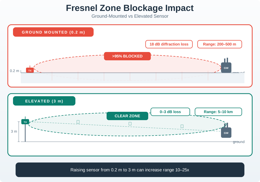
Numerical Analysis (LoRa 915 MHz, 1 km link):
Ground-mounted sensor (h = 0.2m):
| Ground-Mounted Check | Result |
|---|---|
| Fresnel zone radius at midpoint | 9.0 m |
| Sensor height | 0.2 m |
| Ground clearance | 0.2 / 9.0 = 2.2%, far below the 60% requirement |
| Diffraction loss from blockage | About 18 dB |
| Ground reflection loss | About 5 dB |
| Total extra loss | About 23 dB |
| Link budget impact | Original +25 dB margin becomes roughly +2 dB, which is marginal and unreliable |
Elevated sensor (h = 3m):
| Elevated-Sensor Check | Result |
|---|---|
| Fresnel zone radius at midpoint | 9.0 m |
| Sensor height | 3 m |
| Ground clearance | 3 / 9.0 = 33.3%, still below 60% but much better |
| Diffraction loss | About 6 dB |
| Ground reflection loss | About 2 dB |
| Total extra loss | About 8 dB |
| Link budget impact | Original +25 dB margin becomes about +17 dB, which is a reliable link |
Design Guideline: For long-range LoRa/Sigfox sensors, mount antennas at minimum 2-3 meters height, even for ground-level sensing applications (use cables to connect sensors at ground to antenna on pole).
Checkpoint: Protocol and Endpoint Height
You now know:
- Lower-frequency LPWAN links need larger Fresnel clearance than 2.4 GHz Wi-Fi at the same distance.
- A 1 km LoRa 915 MHz link has a 9.0 m midpoint radius; a 0.2 m ground sensor clears only 2.2% of that zone.
- Elevating the same sensor to 3 m still clears only 33.3%, but the example improves the remaining margin from about +2 dB to about +17 dB.
Those numbers explain the common failure pattern. The next examples turn the same calculation into installation choices, cost tradeoffs, and exception handling.
25.12 Practical Deployment Examples
25.12.1 5 km Smart Agriculture LoRaWAN
Problem: Soil sensors at ground level cannot reach gateway 5 km away.
Solution:
- Move sensors to 3m poles with antenna at top
- Use waterproof cables to connect ground-level soil probes to elevated transceivers
- Result: Achieve improved Fresnel clearance, maintain 5 km range
Cost Impact:
- 3m pole per sensor: $50
- Labor for pole installation: $100
- Total per sensor: $150
- ROI: Reliable connectivity vs sensor failures requiring gateway densification ($5,000+ per gateway)
25.12.2 500 m Point-to-Point Wi-Fi
Problem: Direct line-of-sight between buildings, but connection is unstable.
Root cause analysis:
| Root-Cause Check | Result |
|---|---|
| Distance and frequency | 500 m at 2.4 GHz |
| Fresnel radius at midpoint | 17.3 sqrt(0.5 / (4 x 2.4)) = 3.9 m |
| 60% clearance target | 2.4 m |
| Antenna midpoint height | (20 m + 22 m) / 2 = 21 m |
| Tree height in normal season | 18 m |
| Normal-season clearance | 21 - 18 = 3 m, or 77% of the Fresnel zone, so it looks acceptable |
But the connection was still unstable – further investigation revealed seasonal foliage growth added 2-3m to tree canopy height in summer:
| Summer Condition | Result |
|---|---|
| Tree height with foliage | 20 m |
| Clearance | 21 - 20 = 1 m |
| Fresnel clearance | 1 / 3.9 = 26%, which explains the unstable summer link |
Solution:
- Raise Building A antenna to 5m above roof (22m total)
- Midpoint height: (22 + 22) / 2 = 22 m
- Summer clearance: 22 - 20 = 2m (2/3.9 = 51% Fresnel clearance)
- Add 10 dB fade margin for seasonal variation
- Result: Stable year-round link
25.12.3 Example 3: Urban NB-IoT Deployment
Problem: NB-IoT smart parking sensors (ground-level) have poor coverage.
Analysis:
| NB-IoT Check | Result |
|---|---|
| Frequency and distance | 900 MHz over 2 km |
| Fresnel radius | 17.3 sqrt(2 / (4 x 0.9)) = 12.9 m |
| Sensor height | 0.1 m, embedded in pavement |
| Ground clearance | 0.1 / 12.9 = 0.8%, far below 60% |
| Practical effect | Buildings, cars, and urban clutter block the Fresnel zone, adding 20-30 dB loss |
Why NB-IoT still works despite blockage:
- High transmit power: 23 dBm (200 mW) vs LoRa 14 dBm (25 mW) = +9 dB advantage
- Excellent receiver sensitivity: -140 dBm vs LoRa -137 dBm = +3 dB advantage
- Total extra margin: 12 dB compensates for some (but not all) Fresnel blockage
- Multipath propagation: Urban reflections provide alternative signal paths (not available in rural areas)
Result: NB-IoT works for ground-level urban sensors, but LoRa would fail in same conditions without elevation.
25.13 Advanced Worked Examples
Plan Multi-Floor Wi-Fi Coverage
Scenario: A 5-story office building (each floor 40m x 30m) needs Wi-Fi coverage for 200 IoT devices per floor. Building has concrete floors (15 dB attenuation) and drywall partitions (4 dB each). Determine access point placement.
Given:
- Floor dimensions: 40m x 30m = 1,200 sq m per floor
- Concrete floor attenuation: 15 dB per floor
- Drywall partition attenuation: 4 dB
- Wi-Fi 2.4 GHz AP specifications:
- TX power: 20 dBm
- Receiver sensitivity: -90 dBm
- Antenna gain: 3 dBi (omnidirectional)
- Minimum required signal: -75 dBm for reliable IoT operation
Steps:
- Calculate available link budget:
- TX EIRP: 20 + 3 = 23 dBm
- Required received: -75 dBm
- Maximum allowable path loss: 23 - (-75) = 98 dB
- Calculate single-floor horizontal coverage:
- Path loss at 20m (indoor office, n=3.0):
- FSPL at 20m, 2.4 GHz: 20 log(20) + 20 log(2400) + 32.45 = 66 dB
- Environmental excess (n=3 vs n=2): 10(1.0) log(20) = 13 dB
- Total at 20m: 66 + 13 = 79 dB
- Add 2 partitions: 79 + 8 = 87 dB
- Margin at 20m: 98 - 87 = 11 dB (acceptable)
- Test vertical coverage (floor-to-floor):
- Horizontal distance: 10m (directly above/below)
- Path loss at 10m: 60 + 10 = 70 dB
- Add concrete floor: 70 + 15 = 85 dB
- Received power: 23 - 85 = -62 dBm (above -75 dBm, works!)
- One AP can serve devices directly above/below
- Calculate APs needed per floor:
- Effective coverage radius: ~20m (with margin)
- Coverage area per AP: pi x 20^2 = 1,257 sq m
- Floor area: 1,200 sq m
- Minimum APs per floor: 1,200 / 1,257 = 1 (theoretically)
- Add 30% overlap: 1.3 APs per floor
- Recommend: 2 APs per floor for redundancy and load balancing
Result: Deploy 2 APs per floor (10 total) in a staggered pattern. Each AP covers 600 sq m per floor plus partial coverage to adjacent floors. Total received signal ranges from -62 dBm (near AP) to -75 dBm (floor corners), with 13+ dB margin.
Key Insight: Concrete floors attenuate more than horizontal distance in most cases. An AP 10m away through concrete (85 dB loss) has similar path loss to an AP 25m away horizontally (86 dB loss). Plan coverage in 3D, not just 2D floor plans.
LoRaWAN Coverage with Terrain
Scenario: A utility company deploys LoRaWAN water meters across a 15 km x 10 km service area with varied terrain: urban core (2 km radius), suburban ring (5 km radius), and rural edge. A 50m hill blocks line-of-sight to 30% of the rural area. Determine gateway placement strategy.
Given:
- LoRa 915 MHz specifications:
- TX power: 14 dBm (sensor), 27 dBm (gateway)
- Receiver sensitivity: -137 dBm (SF12)
- Antenna gain: 2 dBi (sensor), 8 dBi (gateway)
- Environment path loss exponents:
- Urban (n=4.0), Suburban (n=3.0), Rural (n=2.3)
- Hill height: 50m above surrounding terrain
- Required link margin: 15 dB for 99.9% reliability
Steps:
Calculate uplink budget (sensor to gateway):
- TX EIRP (sensor): 14 + 2 = 16 dBm
- RX (gateway): -137 + 8 = -129 dBm effective sensitivity
- Max path loss: 16 - (-129) - 15 = 130 dB
Determine range by environment:
Urban (n=4.0):
- Path loss = 58 + 40 log(d) = 130 dB
- 40 log(d) = 72, log(d) = 1.8, d = 63m… too short!
- Problem: n=4.0 assumes heavy obstruction
- With gateway at 30m height (above buildings): n reduces to ~3.2
- 58 + 32 log(d) = 130 dB, d = 1.26 km
- Urban coverage radius: ~1.2 km
Suburban (n=3.0):
- 58 + 30 log(d) = 130 dB
- 30 log(d) = 72, log(d) = 2.4, d = 251m… still seems short
- Gateway height advantage: reduces n to 2.6
- 58 + 26 log(d) = 130, d = 2.77 km
- Suburban coverage radius: ~2.8 km
Rural (n=2.3):
- 58 + 23 log(d) = 130 dB
- 23 log(d) = 72, log(d) = 3.13, d = 8.5 km
- Rural coverage radius: ~8.5 km
Address hill obstruction using knife-edge diffraction:
- Hill creates 50m obstruction above the line-of-sight path
- The knife-edge diffraction parameter v depends on how far the obstruction extends into the Fresnel zone
- At 10 km total path (5 km each side), the Fresnel radius at midpoint: r_1 = 17.3 sqrt(10 / (4 x 0.915)) = 28.6 m
- A 50m hill extending well above the line-of-sight path creates significant diffraction loss
- Using the ITU knife-edge model, this obstruction causes approximately 15-20 dB of diffraction loss
- With only 15 dB design margin, this link is marginal or fails
Gateway placement plan:
- Primary gateway: Urban center, 30m rooftop, covers urban + inner suburban
- Secondary gateway: Opposite side of hill, 15m tower, covers blocked rural area (eliminates hill obstruction entirely)
- Tertiary gateway: Far edge of service area for redundancy
Result: 3 gateways provide full coverage with redundancy. Primary gateway at urban center reaches 2.8 km (covers urban + most suburban). Secondary gateway behind the hill eliminates the obstruction shadow zone. Gateway costs: $1,500 each ($4,500 total) versus 15,000 meters served = $0.30/meter for infrastructure.
Key Insight: A single high-elevation gateway in urban areas outperforms multiple low-elevation gateways. The urban n=4.0 path loss exponent assumes ground-level propagation; elevating gateways 30m+ reduces effective path loss exponent by 0.5-1.0, dramatically increasing range. For terrain obstructions, the practical solution is often to place a gateway on the far side of the obstruction rather than trying to engineer a link over it.
Choose LoRaWAN Antenna Height
Step 1: Calculate first Fresnel zone radius
Use: r_1 = 17.3 x sqrt(d / 4f) where d = distance (km), f = frequency (GHz)
| Distance | 868 MHz | 915 MHz | 2.4 GHz |
|---|---|---|---|
| 1 km | 9.3 m | 9.0 m | 5.6 m |
| 3 km | 16.1 m | 15.7 m | 9.7 m |
| 5 km | 20.8 m | 20.2 m | 12.5 m |
| 10 km | 29.4 m | 28.6 m | 17.7 m |
Step 2: Apply 60% clearance rule
Minimum clearance = 0.6 x r_1
Step 3: Add obstacle height
Antenna height = Obstacle height + 60% clearance
Example Decision Tree (LoRa 915 MHz, 5 km link):
For a 5 km, 915 MHz LoRa link, the Fresnel radius is about 20.2 m and the 60% clearance target is 12.1 m.
| Terrain Situation | Design Decision |
|---|---|
| Flat farmland with 2 m crops | Use roughly a 15 m gateway pole: 2 m crops + 12.1 m clearance, rounded up. |
| Urban path with 10 m buildings | Use roughly a 23 m rooftop or mast: 10 m obstacles + 12.1 m clearance, rounded up. |
| Ground sensor at 0.2 m | Clearance is only 0.2 / 20.2 = 1%, so the link is poor. Elevating only the sensor to 3 m gives 15% clearance, still marginal. Elevating both ends is the better design. |
Cost vs Performance Tradeoff:
| Gateway Height | Range (5 km link) | Cost | Use Case |
|---|---|---|---|
| 3m (pole) | 0.5-1 km | $200 | Dense urban |
| 10m (2-story roof) | 2-3 km | $500 | Suburban |
| 15m (pole) | 5-7 km | $1,500 | Rural farmland |
| 30m (tower) | 10-15 km | $5,000+ | Wide-area coverage |
Decision: For most IoT deployments, target 60% Fresnel clearance at the link midpoint. Accept 40-50% clearance only if link budget has 10+ dB margin.
Common Pitfalls
Line-of-Sight Still Needs Fresnel
A clear visual LOS between two antennas does not guarantee adequate RF propagation. The first Fresnel zone may be obstructed by terrain, vegetation, or buildings even when the direct path is visually clear. Fix: calculate the Fresnel zone radius at the link midpoint and verify clearance before antenna installation.
Check Fresnel Beyond Midpoint
The Fresnel zone is widest at the midpoint but must be checked at all points along the path, especially where obstacles are present. Fix: calculate the Fresnel zone radius at each obstacle’s cross-section point along the path, not just at the midpoint.
Account for Earth Bulge Over 5 km
At 10 km, Earth’s curvature adds approximately 1.96 m of effective obstacle height at mid-path. Ignoring this leads to antenna mounting heights that are too low. Fix: add the earth bulge correction (h = d₁ × d₂ / 12.75, with d₁ and d₂ the distances to each end in km and h in metres; at the midpoint of a 10 km link, 5 × 5 / 12.75 = 1.96 m) to Fresnel zone calculations on long links.
The quizzes check whether you can recognize the right action. The final section turns that action into a record an installer or maintainer can use later.
25.14 Fresnel Clearance Record
If you only need the operating rule, use this one: treat Fresnel clearance as measured deployment evidence, not as a drawing beside the link budget.
flowchart TD
  G[Link geometry<br/>frequency, distance, obstacle] --> C[Calculate first zone<br/>and 60 percent target]
  C --> H[Choose antenna heights<br/>plus installation margin]
  H --> F[Verify in field<br/>RSSI, SNR, delivery]
  F --> R{Margin stable?}
  R -- yes --> L[Record baseline<br/>for handoff]
  R -- no --> A[Raise, reroute,<br/>or add gateway]
  L --> T[Retest trigger<br/>growth, mast, roof, terrain]
The important shift is that Fresnel clearance belongs in the same evidence packet as path loss, antenna gain, receiver sensitivity, and measured margin. A link can have a visible center ray and a plausible link budget but still lose reliability when the first zone is cut by crops, terrain, roofs, or vehicles. The field record should therefore state what was calculated, what was installed, and what was measured after installation.
For long outdoor IoT links, clearance is also an operations risk. The geometry changes when a mast is shortened, a gateway moves to another roof edge, a tree canopy grows, or a sensor is remounted lower after maintenance. A good overview record names those retest triggers up front so the link is not treated as a one-time calculation.
- Calculate: For each critical path, record frequency, total distance, obstacle position, first-zone radius, 60% clearance target, antenna heights, and earth-bulge correction when the path is long.
- Verify: Compare the calculation with real terrain, crops, roofs, vehicles, tree growth, mounting tolerances, and measured RSSI or packet-delivery evidence.
- Recheck: Reopen the record when antennas move, vegetation changes, a mast is shortened, a new obstacle appears, or seasonal performance drops.
25.15 Fresnel Field Record
For the 5 km LoRa farm link, write the deployment record as a field decision rather than only a formula result.
Start with the exact path being approved. Record endpoint names, coordinates or site labels, antenna heights above local ground, operating frequency, total path distance, the obstacle that controls clearance, and the season when the measurement was taken. A farm link should include crop height and expected growth; a roof-to-roof link should include parapets, HVAC units, nearby trees, and future roof work. The goal is to make the installation repeatable by someone who was not present during the first survey.
Then separate calculated margin from field margin. The calculated record should show first Fresnel radius, 60% clearance target, obstacle height, selected antenna height, and any earth-bulge correction for longer paths. The field record should show RSSI, SNR, packet-delivery ratio, gateway and sensor identifiers, antenna orientation, weather, and whether the test was run during normal or worst-case obstruction. If the field values disagree with the calculation, the record should say which assumption changed.
- Path: gateway to field sensor, 915 MHz, 5 km, crop height up to 2 m, expected seasonal growth and maintenance vehicle routes.
- Clearance math: first Fresnel radius about 20.2 m at midpoint, 60% target about 12.1 m, so practical antenna planning starts near 14-15 m over crop obstacles.
- Installation decision: mount the gateway on a rooftop or mast, raise sensor antennas above crop height where possible, and keep mounting hardware documented.
- Evidence: record RSSI, SNR, packet delivery, weather, crop state, antenna height, gateway id, sensor id, and any rejected low-height locations.
- Retest trigger: repeat the check after harvest, summer growth, roof work, mast changes, new buildings, or a sustained margin drop.
The release decision should be visible: approved as installed, approved with monitoring, rejected until the antenna is raised, or replaced by a different gateway placement. That decision is more useful than a bare radius number because it tells maintainers what to do when the site changes. If a 15 m gateway mast is the reason the link works, shortening it to 8 m is not a harmless maintenance substitution.
Calculator Discipline
Keep units explicit: distance in km and frequency in GHz for the shortcut formula, or meters and wavelength for the general formula.
Worst-Case Clearance
A link can look acceptable on a clear day and still fail when the worst midpoint obstacle, foliage, or mounting error enters the zone.
25.16 When Visual Line of Sight Still Fails
Visual line of sight checks only the center ray. Radio reliability depends on the volume around that ray because energy arrives through multiple nearby paths and can interfere destructively when obstacles intrude into the first Fresnel zone.
The first zone matters because the receiver does not only see one perfectly straight path. Nearby reflected and diffracted paths can arrive with different phase, and an obstruction inside the zone changes the mix of energy that reaches the antenna. The practical 60% clearance rule is a field design rule: it keeps enough of the dominant zone clear that diffraction and multipath loss do not consume the fade margin that the link budget expected to reserve for weather, interference, and installation tolerances.
Distance and frequency pull in different directions. As distance increases, the zone radius grows with the square root of path length, so a small range extension can require a noticeably taller mast. As frequency increases, wavelength shrinks, so a 2.4 GHz Wi-Fi bridge has a smaller Fresnel zone than a sub-GHz LoRa or Sigfox link at the same distance. That does not make one protocol universally better; it means antenna height, penetration, bandwidth, duty cycle, and margin have to be evaluated together.
The field consequence is that a link budget should not be closed until the geometry is closed. A spreadsheet may show 20 dB of margin, but an unmodeled ridge, crop canopy, roof parapet, or vehicle route can turn that margin into diffraction loss. Conversely, raising one endpoint can improve the effective path enough to avoid adding several gateways. Fresnel clearance is therefore both a radio reliability calculation and an infrastructure cost decision.
- Distance coupling: radius grows with the square root of distance, so a modest extension can require several more meters of clearance.
- Frequency coupling: lower-frequency LPWAN links have larger Fresnel zones than short 2.4 GHz links, even though their path loss and penetration behavior can be better.
- Obstacle coupling: ground, crops, roofs, ridges, and vehicles do not need to block the center ray to consume fade margin.
- Operations coupling: a field record must survive handoff to installers and maintainers, or the next mast change can undo the radio design.
Checkpoint: Field Evidence
You now know:
- A Fresnel decision is not finished until the record includes geometry, the 60% target, antenna heights, and measured RSSI/SNR or delivery evidence.
- The 5 km farm record ties 915 MHz, a 20.2 m radius, a 12.1 m target, and a 14-15 m antenna plan to the same approval decision.
- Retest triggers matter: crop growth, roof work, mast changes, new buildings, and sustained margin drops can invalidate a once-good link.
25.17 Summary
- Fresnel zones require 60% clearance for reliable wireless links – obstacles in the ellipsoid cause diffraction loss
- Lower frequency = larger Fresnel zone: LoRa at 915 MHz needs more clearance than Wi-Fi at 2.4 GHz
- Antenna height scales with distance: 1 km needs 6m height, 5 km needs 13-15m height for the same frequency
- Ground-mounted sensors have 80-90% range reduction due to Fresnel blockage – elevate antennas to 2-3m minimum
- Lower frequencies penetrate buildings better because wavelength enables diffraction around obstacles
- Practical deployments must account for terrain, vegetation, and seasonal changes
Wireless IoT Deployment Checklist
Before deploying wireless IoT devices:
- Calculate link budget for worst-case distance and obstacles
- Measure actual RSSI at planned deployment locations (do not trust theoretical models alone!)
- Add 10-20 dB fade margin for seasonal changes (foliage growth, rain, snow)
- Account for material attenuation: Concrete = 10-15 dB, metal = 20-30 dB per obstacle
- Consider frequency tradeoffs: Lower frequency = better penetration but larger antennas and less bandwidth
- Test in actual environment before large-scale deployment
- Plan for 20-30% coverage overlap to ensure handoff between access points/gateways
Common Mistake: Assuming line-of-sight range applies to indoor/urban deployments. Real range is typically 30-60% of theoretical maximum!
25.18 What’s Next
With Fresnel zone principles and antenna height design under your belt, continue exploring the propagation and link planning series below.
| Topic | Chapter | Description |
|---|---|---|
| Path Loss Fundamentals | Path Loss & Propagation | Understand free-space path loss, log-distance models, and how frequency affects signal attenuation over distance |
| Link Budget Planning | Link Budget and Coverage Planning | Combine transmit power, antenna gain, and path loss into a link budget to predict coverage and select equipment |
| Material Attenuation | Attenuation & RSSI | Quantify how concrete, brick, glass, and vegetation attenuate signals; interpret RSSI measurements in real deployments |
| Shared Channel Collisions | Address Collisions | Explore how collisions in shared wireless channels reduce throughput and learn MAC strategies to manage contention |
| Collision Avoidance Design | Collision Design Strategies | Apply CSMA/CA, TDMA, and frequency planning to design IoT networks that minimize packet loss from channel contention |
| Bandwidth Planning | Bandwidth Requirements | Calculate bandwidth requirements for IoT data streams and select protocols that fit within spectrum allocations |
25.19 Key Takeaway
Fresnel-zone clearance matters because radio links need more than line of sight. Obstructions near the path can reduce margin even when antennas can visually see each other.