Start in a field where water, soil, animals, weather, labor, and market timing all change faster than a fixed schedule can handle. Agriculture IoT is useful when sensing turns uncertainty into a practical action: irrigate, feed, spray, move, repair, or wait with better evidence.
Chapter Roadmap
This chapter moves through the farm decision loop in stages:
First you define the agronomic action before choosing sensors.
Then you map field context, calibration, connectivity, and evidence records so telemetry remains usable.
Next you work through irrigation, livestock, frost, and connectivity examples using the chapter’s own numbers.
Finally you test the decision rules with quizzes, pitfalls, and a compact summary.
Checkpoint callouts recap the main ideas as you go. Deep-dive sections and calculators are optional on a first read; use them when you want to recompute the scenario.
Phoebe’s Field Notes: One Dielectric Constant, Two Jobs In This Field
Phoebe’s Why
Water’s relative permittivity (about 80) towers over dry soil’s (about 4), and that single fact powers two different parts of this chapter. Inside a capacitive probe, water raises the surrounding dielectric constant enough to shift an oscillator’s frequency, which is how the sensor reads volumetric water content at all. Along the LoRaWAN path from a field node to the gateway, that same high-permittivity water sitting in wet soil and crop canopy raises the RF path loss above the textbook inverse-square law – which is why real link-budget planning uses a log-distance model with an exponent above 2, not a bare free-space number. One material property, two engineering consequences, both happening in the same vineyard this chapter maps.
The Derivation
Free-space path loss, from inverse-square spherical spreading into a receive aperture:
Capacitive soil-sensor transduction runs on the same permittivity physics, in the other direction. A mixed soil-water dielectric constant follows a refractive-index mixing rule:
and an LC-oscillator probe reads that out as a frequency shift, since \(f \propto 1/\sqrt{\varepsilon_{mix}}\).
Worked Numbers: This Chapter’s Vineyard
Geometry check: a gateway at the center of the chapter’s 800 m \(\times\) 500 m plot sits \(\sqrt{400^2+250^2}=471.7\) m from the far corner – matching the chapter’s own stated “maximum sensor distance from gateway… 472m” almost exactly.
Free-space loss at 472 m, US915:\(\lambda=c/f=0.328\) m gives \(\mathrm{FSPL}=20\log_{10}(4\pi\times472/0.328)=85.1\) dB.
What the canopy costs: a catalog-typical vegetated exponent \(n=2.8\) raises that to \(106.5\) dB – \(21.4\) dB more than free space, the modeled cost of crop canopy and ground clutter the “line-of-sight” number leaves out.
Fade margin: with a catalog-typical link budget of \(153\) dB (21 dBm TX, \(-132\) dBm SF10 sensitivity), the margin at 472 m is still \(46.5\) dB even under the vegetated model – the single-gateway conclusion holds with real canopy loss, not just a line-of-sight assumption.
What “2 km line-of-sight” spends: even the chapter’s own 2 km rating only consumes \(97.7\) dB of free-space loss, leaving \(55.3\) dB of the budget unused – typical vendor conservatism, and why one gateway comfortably covers a plot far short of its rated range.
Sensor transduction, same physics: the mixing rule gives \(\varepsilon_{mix}=14.0\) at the chapter’s 25% VWC irrigation trigger and \(16.7\) at 30% (the “manually reviews 25-30%” ceiling) – an 8.50% oscillator-frequency shift between those two states, and a 46.5% shift from bone-dry soil to 25% VWC. That is a wide, easily-read signal for the same reason wet canopy costs the radio link so much: water’s permittivity dwarfs dry soil’s.
20.2 Smart Agriculture
Key Concepts
Precision Agriculture: Site-specific crop management using sensor data to vary inputs by field zone rather than treating the whole field uniformly.
Soil Moisture Sensor: Capacitive probe measuring volumetric water content in soil, calibrated per soil type to trigger irrigation accurately.
Variable-Rate Application (VRA): Technology that adjusts fertiliser, pesticide, or water applied based on sensor-mapped spatial variability.
Livestock Biometric Monitoring: Ear-tag, collar, leg-band, or rumen-bolus sensors measuring temperature, activity, location, and rumination so health changes can be detected earlier than manual observation alone.
LoRaWAN Gateway: Long-range wireless receiver that can cover large fields when gateway height, antenna placement, terrain, payload size, and duty-cycle limits support the link budget.
Agronomic Threshold: Crop-specific trigger value (e.g. soil moisture < 25%) that initiates automated irrigation or an alert to the farmer.
Frost Protection System: Network of microclimate sensors and heating/irrigation actuators that activates before ground temperature reaches the crop damage threshold.
20.3 Smart Agriculture Planner
Precision agriculture transforms farming from uniform field treatment to data-driven, site-specific management. IoT sensors enable real-time monitoring of soil conditions, weather, crop health, and livestock well-being across vast agricultural operations.
20.4 MVU: Minimum Viable Understanding
If you remember only 3 things from this chapter:
Precision Over Uniform: Smart agriculture uses site-specific sensor data to treat each field zone individually. Water, fertiliser, and yield outcomes depend on crop value, baseline practice, soil variability, irrigation method, and whether the farm actually changes its operating decisions.
Per-Animal Baselines: Livestock IoT systems must calibrate thresholds per individual animal rather than relying only on herd averages, because a temperature that signals fever in one cow may be normal for another. Temperature becomes more useful when it is interpreted with activity, rumination, location, and recent heat stress.
Connectivity Is a Farm Design Choice: LoRaWAN often fits low-data-rate field sensors because the farm can deploy its own gateway, but NB-IoT/LTE-M, Wi-Fi, BLE, private cellular, and satellite can be better choices for animals, machinery, barns, greenhouses, or remote properties.
Quick Decision Framework: When planning agricultural IoT, ask: “What is the economic value per hectare of this crop?” High-value crops (wine grapes, citrus) justify 2-3x higher sensor density than commodity crops (corn, wheat).
20.5 Learning Objectives
By the end of this chapter, you will be able to:
Explain the precision agriculture IoT stack from sensing to actuation
Calculate optimal sensor spacing for soil moisture monitoring
Configure livestock health alert thresholds using individual animal baselines
Design frost protection decision systems with microclimate monitoring
Avoid connectivity and sensor failure pitfalls in agricultural deployments
20.6 Agronomic Decision First
A smart agriculture system is useful only when it changes a farm action: irrigate a zone, open a greenhouse vent, treat an animal, move a herd, protect a crop from frost, service a pump, or hold off on applying fertiliser. The sensor is not the product by itself. The product is the decision loop that connects field conditions to timely action.
For a soil-moisture deployment, that loop includes calibrated capacitive or tensiometer readings, soil texture, root-zone depth, crop growth stage, weather forecast, irrigation valve state, flow confirmation, and a way for the operator to override the recommendation. For livestock, it includes animal identity, normal baseline, tag or bolus health data, activity change, location, and a veterinary workflow that makes the alert actionable.
Figure 20.1: Smart agriculture system boundary: field sensors, gateways, cloud analytics, dashboards, and irrigation commands preserve field-zone identity, calibration context, and action confirmation from measurement through farm response.
The economic case depends on the crop, herd, and operating constraint. A vineyard, almond orchard, greenhouse, dairy herd, or remote grazing operation may justify more sensing than a low-margin commodity field because the value of avoiding crop stress, disease, animal loss, or wasted water is higher. The same soil sensor can be valuable in one field and marginal in another if irrigation water is cheap, soil variation is low, or workers will not change the schedule.
Field crops: place sensors by management zone, soil type, slope, and crop value rather than by a simple grid.
Livestock: treat tags, collars, leg bands, and rumen boluses as baseline trackers, not standalone diagnosis devices.
Controlled environments: connect temperature, humidity, CO2, light, substrate moisture, vents, heaters, and irrigation setpoints into one control model.
The beginner mistake is to treat agriculture IoT as a hardware shopping list. The useful framing is narrower: define the agronomic decision, name the data needed before the decision, name the action after the decision, and prove that the loop changes yield, input use, labor, welfare, compliance, or risk. A dashboard that reports conditions after the crop is stressed is monitoring; a system that changes the irrigation or treatment plan in time is operational IoT.
20.7 Design Field Loop First
Start with a map of the operation. Mark soil zones, pump locations, valve groups, power sources, gateway candidates, barn walls, canopy height, low frost pockets, animal routes, and places where workers already inspect equipment. That map determines whether LoRaWAN, NB-IoT/LTE-M, BLE tags through readers, Wi-Fi, private cellular, or satellite backhaul is the right fit.
A practitioner should also map the season. Installation before planting, sensor calibration during wet and dry conditions, gateway surveys before canopy growth, and actuator testing before irrigation demand are different tasks. If the deployment waits until the crop is already stressed, there may be no safe opportunity to tune thresholds. For livestock, baseline learning needs enough normal days to separate illness, heat stress, calving, feeding changes, and ordinary movement patterns.
Choose the decision threshold. Define what reading changes action, such as volumetric water content below a crop-stage threshold, rumination dropping from an animal baseline, or leaf-wetness duration crossing a disease-risk rule.
Prove the measurement. Calibrate soil sensors against gravimetric samples, verify temperature probes in the installed enclosure, check antenna RSSI/SNR at crop height, and record battery behavior under the chosen reporting interval.
Close the loop. Confirm that valve state, pump current, flow meter pulses, tag check-ins, or greenhouse actuator feedback show whether the command actually changed the physical system.
The implementation details matter. A LoRaWAN Class A soil node that sends a 12-byte payload hourly has a different power and latency profile than a cellular cattle collar with GNSS fixes, or a greenhouse controller using Modbus, MQTT, or OPC UA over wired Ethernet. Design each data path around the farm action it supports.
Commissioning should produce evidence, not just installed devices. Keep a gateway coverage map, a sensor calibration record, a threshold rationale, a battery-life estimate, and an operator escalation path. Test failure modes deliberately: blocked gateway antenna, dead battery, stuck valve, missing animal tag, stale weather feed, and a sensor that flatlines after being dislodged. The farm team needs to know whether the system will fail safe, alert a person, or continue with conservative defaults.
20.8 Agriculture Data Needs Context
Agricultural telemetry is easy to misread when context is stripped away. Store the sensor identifier, calibration curve, soil zone, installation depth, units, timestamp, battery state, firmware version, quality flag, and nearby weather station context with each reading. For geospatial data, preserve coordinates, field boundary, management zone, and equipment pass when data flows into a time-series store or farm-management platform.
Connectivity and power choices also shape the data model. LoRaWAN airtime and duty-cycle limits favor compact, infrequent telemetry. NB-IoT and LTE-M support wider coverage where cellular service exists but add carrier dependency and power budget pressure. BLE livestock tags may need barn readers or mobile gateways. Satellite can cover remote ranches but changes message frequency and cost assumptions. None of these technologies removes the need for calibration, identity, and physical confirmation.
Under the hood, a field reading is rarely a single number. A moisture value may need raw sensor counts, calibration version, soil temperature, installation depth, salinity warning, last rainfall, irrigation event id, and the management zone boundary used by the control rule. A livestock event may need animal id, device placement, firmware, last gateway contact, activity window, baseline model version, and whether staff confirmed the animal was checked. Without that metadata, analytics can confuse a bad sensor with a dry field or a missing tag with a healthy animal.
Identity: bind every sensor, valve, animal tag, gateway, and actuator to the field, herd, or zone it claims to represent.
Quality: flag stale values, impossible jumps, flatlined sensors, missed packets, and readings outside calibrated range before analytics use them.
Control: separate recommendation, command sent, command acknowledged, actuator moved, and physical effect confirmed as different states.
Real deployments often combine farm systems with general IoT infrastructure. ChirpStack or a carrier LoRaWAN network server may feed MQTT, HTTP webhooks, AWS IoT Core, Azure IoT Hub, TimescaleDB, InfluxDB, or a farm-management platform. The integration should preserve units, timestamps, field identity, and quality flags across those systems. If the time-series database stores a number but drops the calibration curve or field boundary, downstream dashboards may look precise while making unsafe agronomic recommendations.
Checkpoint: Farm Decision Loop
You now know:
Agriculture IoT should start from the action: irrigate a zone, open a vent, treat an animal, move a herd, or hold off on fertiliser.
Useful soil-moisture records preserve the sensor identifier, calibration curve, soil zone, installation depth, units, timestamp, battery state, firmware version, and quality flag.
Connectivity is part of the design, not an afterthought: LoRaWAN, NB-IoT/LTE-M, BLE, Wi-Fi, private cellular, and satellite each change power, cost, and data assumptions.
20.9 For Beginners: Smart Agriculture
Smart agriculture means using small electronic sensors placed in fields and on animals to collect information like soil moisture, temperature, and animal health. Think of it like giving a farmer a set of digital eyes and ears spread across the entire farm, so instead of guessing when to water or checking every cow by hand, the farmer gets instant alerts on a phone or tablet when something needs attention.
20.10 For Kids: Meet the Sensor Squad!
Smart farming is like giving plants and animals their own doctors and weathermen who watch over them 24/7!
20.10.1 Sunny Acres Farm Sensors
Farmer Emma woke up worried. Her tomato plants looked droopy yesterday, and she wasn’t sure why. But this morning, she had five new helpers - the Sensor Squad had arrived at Sunny Acres Farm!
Thermo the Temperature Sensor buried himself right in the soil next to the tomato roots. “Aha! The soil temperature dropped to 45 degrees last night - that’s too cold for tomatoes! They need at least 55 degrees to be happy.” Farmer Emma had no idea - the air felt warm, but underground was different!
Over in the cornfield, Sunny the Light Sensor was measuring something special. “These corn plants in the corner aren’t getting enough sunlight because that big oak tree shades them in the afternoon. They’re growing more slowly than the others!” Now Farmer Emma knew exactly which plants needed extra help.
The coolest sensor was the Moisture Monitor (Thermo’s cousin). It could tell how wet or dry the soil was deep underground. “Section 3 is thirsty - only 15% moisture! But Section 7 already has 45% moisture - no watering needed there!” Instead of watering the whole field the same amount, Farmer Emma could give each section exactly what it needed and avoid wasting water where the soil was already wet.
Power Pete the Battery Manager made sure all the sensors could work even in the middle of huge fields with no power outlets. “We use tiny solar panels and super-efficient batteries that last for YEARS without changing!”
At the end of the week, Farmer Emma looked at all the data on her tablet. “The Sensor Squad saved me water, helped me grow healthier plants, and even kept my cows healthy. It’s like having a thousand eyes watching over my whole farm!”
20.10.2 Key Words for Kids
Soil Moisture: How much water is in the dirt; sensors can tell if plants are thirsty.
Precision Agriculture: Giving each plant exactly what it needs instead of treating the whole field the same.
Crop Monitoring: Using sensors to check on plants’ health without walking through every row.
Livestock Tracking: Using special sensors on farm animals to know where they are and if they’re healthy.
20.11 The Evolution of Precision Agriculture
Agriculture has evolved through distinct technology phases, each building on the previous. IoT represents a transformational leap - not just incremental improvement.
The Three Eras of Agricultural Technology:
Past: ploughs, GMO crops, and GPS tractors created incremental yield improvements, but their data often stayed in separate systems.
Present: weather stations, soil sensors, and plant monitors provide real-time environmental data, but raw streams can overwhelm farmers.
Future: UAV drones, AI analytics, and autonomous equipment can turn measurements into recommendations when connectivity and skills are in place.
Why IoT Is Different:
Past technologies gave farmers more data but not more insight
Connected sensors provide real-time visibility but can overwhelm
IoT + AI integration transforms data into actionable recommendations
20.12 Smart Vineyard Irrigation
Let’s trace how a smart irrigation system works from sensor reading to water valve actuation:
Step 1: Sensing (Field Layer)
50 soil moisture sensors buried 30 cm deep across 20-hectare vineyard
Each sensor measures volumetric water content (VWC) every 15 minutes
Compares to thresholds: Alert if VWC < 25% or > 80%
Step 4: Analytics (Cloud Layer)
Cloud platform receives aggregated data every hour (not every 15 min)
ML model predicts tomorrow’s irrigation needs based on:
Current soil moisture trends
Weather forecast (temperature, rainfall)
Crop growth stage (flowering vines need more water)
Output: “Zone 3 needs 8mm irrigation tomorrow at 6 AM”
Step 5: Actuation (Control Layer)
At 6 AM, system sends command to Zone 3 solenoid valve: “Open for 45 minutes”
Flow meter confirms delivery of 8mm water depth
If sensor #23 VWC doesn’t rise above 30% within 2 hours → alert farmer (possible sensor burial or valve failure)
Key Insight: The system loops continuously — actuation affects sensors, sensors inform next actuation. Without the sensor feedback loop, the farmer would irrigate on a fixed schedule regardless of actual soil conditions.
Common Failure Point: If sensor #23 is poorly installed (air gap around sensor), it reads 15% VWC even when soil is saturated. System over-irrigates, wastes water, and creates root rot. This is why sensor installation quality matters as much as sensor technology.
20.13 Irrigation Action Record
Use one row to turn a sensor reading into a decision that another person could audit later:
Sensor and zone: Sensor #23, vineyard Zone 3.
Calibrated reading: 26% volumetric water content at 2:45 PM.
Threshold rule: Irrigate when VWC is below 25%; review manually from 25-30%.
Action taken: Schedule 8 mm irrigation at 6 AM; require flow-meter confirmation.
Follow-up evidence: VWC should rise above 30% within 2 hours, or alert for valve or installation fault.
The record is useful because it keeps the agronomic threshold, actuator command, and validation signal together. If the field result disagrees with the model, the team can adjust calibration or placement instead of blaming the entire IoT system.
Checkpoint: Irrigation Evidence
You now know:
The vineyard example uses 50 soil-moisture sensors across 20 hectares, with 12-byte readings every 15 minutes.
Sensor #23 moves from a raw 28% reading to a calibrated 26% reading; the rule irrigates below 25% and manually reviews the 25-30% range.
A complete action record ties the 8 mm irrigation command to 6 AM timing, flow-meter confirmation, and a follow-up check that VWC rises above 30% within 2 hours.
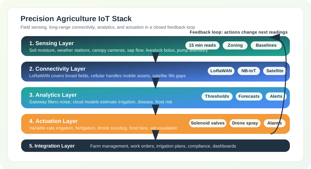
20.14 Precision Agriculture IoT Stack
Sensing: soil-moisture probes, sap-flow sensors, and weather stations show when and where irrigation is needed.
Connectivity: LoRaWAN, satellite, and other links move field readings across large properties with few gateways when the link budget allows it.
Analytics: edge and cloud models can predict yield risk or disease pressure when they keep calibration and field context.
Actuation: variable-rate irrigation and drone spraying apply inputs only where the farm has evidence to act.
Integration: farm-management software brings sensor, equipment, and operating records into one decision surface.
For larger farms, the integration layer is often a context platform rather than a single dashboard. A gateway may translate field protocols into a shared model, a context broker may keep the latest state for fields, sensors, pumps, animals, and equipment, and an export service may archive selected records for research or compliance. FIWARE NGSI-LD, OGC SensorThings, MQTT topic contracts, or farm-management APIs can all support that pattern when the record still preserves device identity, location, timestamp, unit, calibration state, and the rule that changed an irrigation or husbandry decision.
Figure 20.2: Precision Agriculture IoT Architecture - End-to-end data flow from field sensors to automated actuation
Economic Impact:
Precision irrigation can reduce avoidable watering when the baseline system over-irrigates or misses field-zone differences
Variable-rate fertiliser and pesticide programs can reduce input waste when maps, calibration, and application equipment are trustworthy
Yield benefits depend on crop stress, weather, disease pressure, soil variability, and whether the farm changes operations in time
Cost savings should be estimated from the farm’s water price, pump energy, labour, crop value, equipment cost, and maintenance burden
20.15 Livestock and Controlled Ag
Agricultural IoT often moves beyond field irrigation into animal health and climate-controlled production:
Rumen bolus monitoring places an ingestible sensor in cattle to track stomach temperature, pH, activity, and rumination. Value comes from detecting fever, acidosis, or heat stress 24-48 hours before visible symptoms, but thresholds must be tuned per animal to avoid false alerts.
Greenhouse climate control combines temperature, humidity, CO2, light, and substrate-moisture sensors with heating and ventilation commands. The ROI depends on closing the loop: sensors without automated setpoint changes produce reports, not savings.
Poultry-house monitoring watches ammonia, floor-level temperature, humidity, and ventilation balance. Small feed conversion ratio improvements compound quickly at flock scale, so sensor placement must capture microclimates at bird height rather than only ceiling conditions.
Design implication: start with the farm decision that changes action – treat an animal, open a vent, irrigate a zone – then work backward to sensor placement, connectivity, power budget, and alert thresholds.
20.16 Putting Numbers to It
Let’s calculate a scenario for water savings from precision irrigation on a corn farm:
Given: A 1,000-acre corn field using flood irrigation applies 24 inches of water per growing season.
Volume calculation:
Baseline seasonal water volume: 1,000 acres x 24 inches x 1 foot / 12 inches x 43,560 square feet per acre = 87.12 million cubic feet.
Gallon conversion: 87.12 million cubic feet x 7.48 gallons per cubic foot = 651.7 million gallons.
Precision-irrigation scenario: 25% savings x 651.7 million gallons = about 163 million gallons saved per season.
At an assumed agricultural water cost of $0.002 per gallon, the scenario saves about $326,000 per season.
Treat that as a worked estimate: the real result depends on local water pricing, pumping energy, crop response, and whether the control loop prevents both over-watering and under-watering.
The mistake: Trusting automated irrigation systems to function correctly without monitoring sensor health, leading to massive water waste or crop damage when sensors fail silently.
Symptoms:
Water bills or pump-energy costs much higher than expected with no corresponding crop benefit
Waterlogged fields in some zones while other zones show drought stress
Sensors reporting constant values (stuck readings) that do not change with weather
Root rot, fungal disease, or nutrient leaching in over-watered areas
Why it happens: Soil moisture sensors degrade over time from salt buildup, physical damage from tillage equipment, rodent damage to cables, or battery depletion. Many systems lack sensor health monitoring and continue operating on stale or failed readings.
The fix: Implement sensor health monitoring that flags readings outside expected ranges or unchanging values. Deploy redundant sensors in critical zones. Configure fail-safe behavior that alerts operators rather than continuing irrigation on suspect data. Schedule regular sensor calibration and physical inspection (monthly during growing season).
Prevention: Design systems with sensor self-test capabilities and plausibility checks (for example, soil moisture should correlate with recent rainfall). Set up automated alerts when sensor readings diverge from weather station data. Include sensor replacement in annual maintenance budgets (typical lifespan is 2-5 years depending on soil chemistry).
20.19 Agricultural Connectivity Gaps
The mistake: Deploying IoT sensors across large fields without proper wireless coverage assessment, resulting in data loss, delayed alerts, and irrigation decisions based on incomplete information.
Symptoms:
Sensors in remote field corners reporting intermittently or not at all
Data gaps during critical periods (frost events, pest outbreaks, irrigation cycles)
Gateway overload during peak transmission times causing packet loss
Battery drain from repeated transmission retries in weak signal areas
Why it happens: Agricultural fields often span hundreds of hectares with varying terrain, vegetation density, and soil moisture levels that affect radio propagation. Initial deployments tested during dormant season may fail when crop canopy develops and attenuates signals.
The fix: Conduct RF site surveys during peak growing season when vegetation is densest. Deploy mesh networks or repeaters to extend coverage to remote areas. Use LoRaWAN or other long-range protocols designed for agricultural distances. Position gateways on elevated structures (silos, poles, pivot towers) for line-of-sight coverage.
Prevention: Plan 20-30% coverage margin to account for seasonal variation and sensor additions. Map field topology and identify potential dead zones before deployment. Test coverage with portable devices at all planned sensor locations before permanent installation.
20.20 Worked Examples
20.21 Vineyard Sensor Spacing
Scenario: A Napa Valley vineyard manager is deploying a precision irrigation system across a 40-hectare premium Cabernet Sauvignon vineyard with varying soil types (clay loam in low areas, sandy loam on slopes).
Given:
Field dimensions: 800m x 500m (40 hectares)
Soil variability: 3 distinct zones identified by soil sampling
Vine spacing: 2m x 3m (1,667 vines per hectare)
Water stress sensitivity: High (premium wine grapes)
LoRaWAN gateway range: 2km line-of-sight
Budget: $12,000 for sensors (excluding gateway)
Steps:
Calculate minimum sensor density for soil variability: With 3 soil zones across 40ha, each zone averages 13.3ha. Research indicates capacitive soil moisture sensors have an effective sensing radius of 30-50cm, but management zones should have 3-5 sensors minimum for statistical confidence.
Minimum sensors per zone: 5
Total minimum: 15 sensors
Adjust for topographic variation: Slopes cause moisture gradients. Add 2 sensors per zone for slope monitoring.
Adjusted total: 15 + 6 = 21 sensors
Calculate sensor spacing: 40ha = 400,000 m². With 21 sensors: 400,000/21 = 19,047 m² per sensor ≈ 138m average spacing.
Verify LoRaWAN coverage: Maximum sensor distance from gateway at field center: 472m. Well within 2km range. Single gateway sufficient.
Budget verification: At $400-500 per sensor node (capacitive sensor + LoRa radio + solar + enclosure), 21 sensors = $8,400-$10,500. Within budget.
Result: Deploy 21 soil moisture sensors in a variable-density grid. Planning estimates in this scenario: - Water savings: modelled as a reduction from baseline flood irrigation after calibration and valve-control checks - Quality improvement: tighter soil-moisture control should reduce avoidable variation in grape ripening, but harvest quality still depends on weather, disease pressure, and viticulture practice - ROI: calculate from local water cost, pump energy, labour, grape value, node cost, and maintenance rather than assuming a universal payback
Key Insight: Sensor spacing in precision agriculture is driven by soil variability and crop value, not field size alone. High-value crops like wine grapes justify 2-3x higher sensor density than commodity crops.
Scenario: A 500-head dairy operation in Wisconsin is configuring rumen bolus temperature thresholds to detect illness early while minimizing false alerts that waste veterinary time.
Given:
Herd size: 500 lactating Holstein cows
Normal rumen temperature range: 38.5-39.5°C (baseline varies by individual)
Fever threshold (clinical): >39.5°C sustained for >4 hours
Missed mastitis case cost: $450 average (treatment + lost production)
Steps:
Establish individual baselines: Each cow has a unique baseline temperature. After 14-day calibration period, system calculates rolling 7-day average for each animal.
Cow #234 baseline: 38.8°C
Cow #456 baseline: 39.2°C
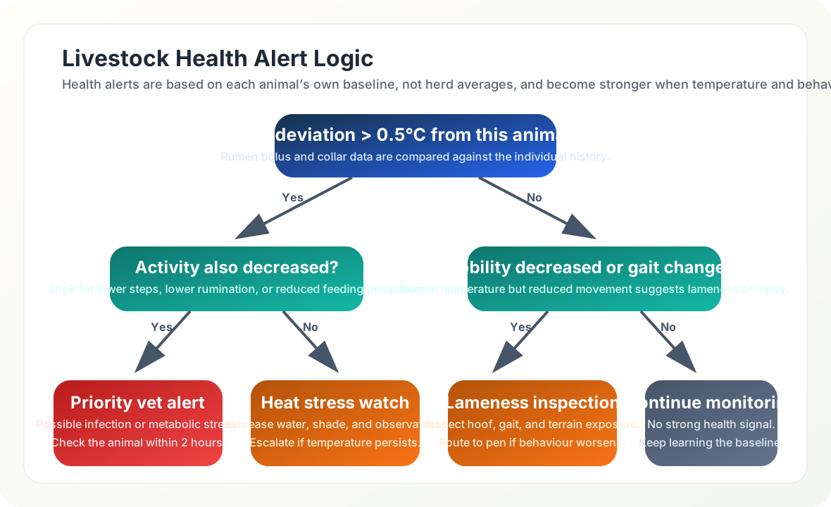
Configure adaptive thresholds: Rather than absolute threshold (>39.5°C for all), use deviation from individual baseline.
Alert trigger: Baseline + 0.5°C sustained for 3+ hours
High-priority alert: Baseline + 0.8°C sustained for 2+ hours
Add activity correlation: Combine temperature with activity data to reduce false positives.
Temperature rise + decreased rumination = likely illness (priority alert)
Temperature rise + normal activity = possible heat stress (monitor)
Calculate expected alert accuracy:
With individual baselines in this scenario: false positive rate drops from 8/day to 1.5/day
True illness detection improves because cows with lower normal baselines are no longer hidden by a herd-average threshold
Lead time is measured against the farm’s own visual-inspection records, not assumed from the sensor alone
Net benefit: ~$3,500/month improvement over factory settings
Result: Custom threshold configuration reduces false alerts in the scenario and can surface health changes earlier than visual observation when the farm validates the alert against veterinary outcomes. The annual value should be calculated from local labour, veterinary, treatment, milk-production, and herd-management data.
Key Insight: Livestock IoT systems require per-animal baseline calibration, not herd-level thresholds. A temperature that indicates fever in one cow may be normal for another. Multi-sensor correlation (temperature + activity + rumination) dramatically improves alert accuracy over single-parameter thresholds.
20.23 Citrus Frost Protection Logic
Scenario: A Florida citrus grower is deploying an IoT-based frost protection system to automate irrigation and wind machine activation across a 300-acre Valencia orange grove, protecting a $2.4 million crop from freeze damage.
Given:
Grove area: 300 acres (121 hectares)
Tree density: 145 trees per acre (43,500 trees total)
Crop value: $8,000 per acre ($2.4 million total)
Critical temperature: 28°F (-2.2°C) for 4+ hours causes fruit damage
Frost events per season: 8-12 (December through February)
Protection methods: Overhead irrigation (180 GPM/acre) and wind machines (1 per 10 acres)
Current false alarm rate: 40% (unnecessary protection activations)
Steps:
Deploy microclimate sensor network:
In-canopy sensors: 30 units at fruit height (1 per 10 acres)
Dew point sensors: 6 units at low-lying areas (cold air pools)
Soil temperature sensors: 6 units (thermal mass indicator)
Wind speed/direction: 4 sensors at grove corners
Cloud cover/sky temperature: 1 infrared sensor
Total sensor cost: $18,500
Develop prediction algorithm (4-hour forecast):
Input variables: Current temp, dew point, wind speed, cloud cover, soil temp
Damage prevention from faster response: $48,000/season
Result: In this scenario, the IoT frost protection system delivers estimated annual benefits of $108,588: - Wind machine fuel savings: $45,900 - Water savings: $14,688 - Damage prevention: $48,000 - System cost: $26,500 installation + $3,500/year maintenance - First-year payback depends on installation timing, maintenance, crop value, frost frequency, and how much unnecessary activation remains
Key Insight: Frost protection economics are dominated by false alarm costs. IoT microclimate monitoring reduces false alarms by 60% through spatial temperature mapping that identifies which zones actually need protection, rather than treating the entire grove uniformly based on a single weather station.
Checkpoint: Worked Farm Scenarios
You now know:
The water-savings calculator starts from 1,000 acres, 24 inches of seasonal water, 651.7 million gallons, and a 25% precision-irrigation scenario.
The vineyard spacing example expands from 15 minimum sensors to 21 sensors after slope monitoring, for about 138 m average spacing.
Livestock alerting works from individual baselines: Cow #234 starts at 38.8°C, Cow #456 at 39.2°C, and the adaptive trigger adds 0.5°C for 3+ hours.
The frost scenario protects 300 acres and a $2.4 million crop while reducing false activations by 60%.
20.24 Livestock Monitoring Technologies
Connected livestock monitoring transforms animal husbandry through continuous health and location tracking:
Sensor Types:
Ear tag: external ear devices combine GPS, temperature, and accelerometer readings for location, activity, and identification.
Collar: neck devices use GPS, accelerometers, and microphones to infer grazing behavior, rumination, and estrus.
Rumen bolus: permanent stomach devices measure temperature, pH, and activity for health monitoring and estrus detection.
Leg band: ankle accelerometers and pedometers support lameness detection and activity monitoring.
Key Applications:
Estrus detection: combine activity, rumination, and history so staff can prioritise checks instead of relying only on visual observation
Calving alerts: use movement, posture, and temperature changes to notify staff before or during labour
Illness detection: watch deviations from each animal’s baseline so subtle changes are not lost in herd averages
Grazing optimization: Track which pastures are being utilized
Theft prevention: Geofencing alerts when animals leave property
Figure 20.3: Livestock Health Alert Decision Tree - How IoT sensor data drives veterinary response prioritization
20.25 Connectivity for Agricultural IoT
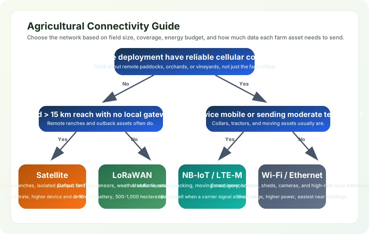
LoRaWAN: 2-15 km range, 5-10 year battery targets, and 0.3-50 kbps data rates make it a strong fit for soil sensors and weather stations.
Sigfox: 10-50 km range and 100 bps payloads fit simple status sensors where a Sigfox network is available.
NB-IoT: cellular-coverage range, 5-10 year battery targets, and roughly 100 kbps service can support livestock tracking where carriers cover the farm.
Satellite: global reach and 1-10 kbps links can serve remote ranches, but message frequency, terminal cost, and battery life need careful design.
Wi-Fi: 50-100 m range and high data rates suit barns and greenhouses with local power, not wide battery-powered fields.
Why LoRaWAN Often Fits Field Sensors:
A self-deployed gateway can cover large open areas when the link budget, antenna height, terrain, and crop canopy allow it
Small payloads and infrequent reporting can support multi-year batteries, especially for Class A devices that mostly sleep
Unlicensed spectrum avoids carrier contracts, but still requires regional frequency planning and duty-cycle awareness
Node cost varies with enclosure, sensor quality, power system, certification, installation labour, and support model
Figure 20.4: Agricultural IoT Connectivity Selection Guide - Choosing the right wireless technology based on deployment requirements
Checkpoint: Connectivity Choices
You now know:
LoRaWAN fits many field sensors because the farm can deploy its own gateway, payloads are small, and battery targets can be 5-10 years.
Satellite can reach remote ranches, but its 1-10 kbps links change message frequency, terminal cost, and battery design.
Wi-Fi’s 50-100 m range and high data rates suit barns and greenhouses with local power, not wide battery-powered fields.
20.26 Knowledge Check: Agricultural IoT
20.27 Soil Moisture Calibration Pitfall
The Mistake: Installing capacitive soil moisture sensors across a field using the manufacturer’s default calibration curve, then making irrigation decisions based on uncalibrated readings that can be off by 20-40% in actual volumetric water content.
Why This Happens: Soil moisture sensors ship with a generic calibration (often for sandy loam or laboratory test media). Different soil types – clay, silt, sand, organic matter – have vastly different dielectric properties, meaning the same sensor reading (say, 50% VWC) corresponds to completely different actual moisture levels in clay versus sandy soil.
Scenario: A California almond grower deploys 80 capacitive sensors across a 100-hectare orchard with mixed soil types: - Zone A (sandy loam): Sensor reads 35% VWC, actual VWC = 32% (close enough) - Zone B (clay loam): Sensor reads 35% VWC, actual VWC = 48% (13 points over!) - Zone C (sandy): Sensor reads 35% VWC, actual VWC = 22% (13 points under!)
The grower set irrigation thresholds at “below 30% VWC” based on Zone A. Result: Zone B was over-watered, wasting water and increasing root-disease risk, while Zone C was under-watered and exposed to avoidable crop stress.
Why Soil Type Matters:
Pure sand: a low dielectric constant, around 3-5, can make water look artificially dry.
Clay: a high dielectric constant, around 15-25, can make soil look wetter than it is.
Organic matter: variable dielectric behavior, often around 10-20, is unpredictable without calibration.
Saline soils: very high conductivity and dielectric effects can cause severe moisture over-reading.
The Fix:
Proper Calibration Workflow:
Soil Sampling: Collect representative soil samples from each zone (3-5 zones per field based on soil survey maps)
Lab Analysis: Send samples for texture analysis (sand/silt/clay percentages)
Gravimetric Calibration:
Take soil cores next to installed sensors at 5 different moisture levels
Weigh wet, dry at 105°C for 24 hours, calculate actual VWC
Record sensor readings at each actual moisture level
Generate zone-specific calibration curve
Adjust Sensor Firmware: Apply zone-specific calibration coefficients to sensor nodes
Validation: Repeat spot-checks monthly during first season
Quick Field Check (if lab calibration isn’t feasible): - Irrigate a small test area to field capacity (soil saturated, then drained) - Wait 24 hours, take sensor reading - Simultaneously take soil core, perform gravimetric test - Calculate offset: Actual VWC - Sensor VWC = Correction factor - Apply correction to all sensors in that zone
Cost-Benefit:
Lab calibration: $200-400 per zone (3-5 samples)
Improves irrigation decisions by separating actual soil-water status from sensor bias
For a 100-hectare farm, calibration value should be estimated from local water price, pumping energy, crop value, and the cost of wrong irrigation decisions
Key Warning Signs Your Sensors Need Calibration:
Sensors in different field zones show identical readings despite visible moisture differences
Irrigation controllers never reach your set thresholds (always “too dry” or “too wet”)
Some zones develop root disease (over-watering) while others show drought stress (under-watering)
Sensor readings don’t respond to rainfall within 24 hours
Prevention: Always specify “soil-specific calibration” in procurement contracts. Budget $50-100 per sensor for calibration – cheaper than one failed crop or wasted water season.
20.28 Quiz: Agricultural IoT Concepts
20.29 Quiz: Agriculture IoT Deployment
Common Pitfalls
20.30 Livestock Context
Setting alert thresholds based on average herd values rather than individual animal baselines causes both false positives (healthy animals flagged) and missed detections (sick animals within herd range). Each animal has a personal normal temperature range of ±0.5°C. Calibrate per individual during a healthy baseline period and store per-animal thresholds rather than a single herd value.
20.31 Soil Type Calibration Pitfall
Soil moisture sensors read the same raw value as completely different water contents in clay versus sandy soils. Deploying without soil-specific calibration curves can result in irrigating already-saturated clay fields while under-watering sandy zones. Perform volumetric water content calibration per soil zone before deploying production thresholds.
20.32 Single Gateway Farm Pitfall
A single LoRaWAN gateway rarely covers an entire farm due to terrain, vegetation, and building attenuation. Blind spots cause data gaps that look like ‘no change’ to the analytics platform. Conduct a site survey with portable hardware before finalising gateway placement and add redundant gateways for critical sections.
20.33 Label the Diagram
20.34 Code Challenge
20.35 Summary
Smart agriculture IoT delivers value when precision management changes real farm decisions:
Soil moisture monitoring helps avoid over-watering and under-watering when sensors are calibrated by soil zone
Livestock health sensors surface baseline deviations so staff can prioritise animal checks and veterinary follow-up
Frost protection systems use microclimate data to target protection actions instead of treating the entire grove from one weather station
Variable-rate application adjusts fertiliser, pesticide, or water by field zone when maps and equipment are trustworthy
Connectivity: LoRaWAN often fits long-range, low-data-rate field sensors; other technologies fit barns, machinery, animals, or remote ranches
The key to agricultural IoT success is matching sensor density to soil variability and crop value, not field size alone. High-value crops may justify denser sensing and automation than commodity crops, but the business case should be calculated from local operations.
20.36 Concept Relationships: Smart Agriculture
Soil moisture monitoring relates water savings to sensor calibration: irrigation decisions require soil-specific calibration curves for clay, sand, loam, organic matter, and salinity effects.
LoRaWAN fit relates long range to battery life: large fields may favor LoRaWAN over Wi-Fi when payloads are small, reporting intervals are sparse, and gateway placement is strong.
Variable-rate application relates sensor density to crop value: higher-value crops can justify denser sensor grids, while lower-margin commodity crops usually need simpler instrumentation.
Livestock health sensors relate early detection to false alarms: temperature, activity, and rumination sensors require per-animal baselines and staff workflow tuning to avoid alert fatigue.
Cross-module connection: Agricultural IoT integrates sensors (Module 2), LoRaWAN (Module 4), and edge processing (Module 5). See LPWAN Fundamentals for protocol comparison.
IoT sensors in agriculture enable precision monitoring of soil moisture, crop health, and livestock well-being, but the value comes from calibrated, site-specific action rather than from the sensor reading alone.
20.39 What’s Next
Smart Manufacturing: Industrial IoT, predictive maintenance, and supply chain visibility.
Healthcare IoT: Patient monitoring parallels livestock health monitoring.
Smart Grid: Rural energy management for agricultural operations.
20.40 Key Takeaway
Agricultural IoT succeeds when sensing, connectivity, power, and farm operations are designed together. A technically accurate reading is only valuable if it reaches the grower in time to change irrigation, fertilization, disease response, or equipment use.

 Checkpoint: Farm Decision Loop