16 Smart City Service Governance Contracts
16.1 Start With the Story
Begin with a city sensor that reports data but does not yet define who responds. This contract chapter turns smart-city ideas into service governance: the useful story is the handoff from measurement to accountability, response time, public communication, and long-term stewardship.
16.2 Learning Objectives
After this page, you should be able to:
- Explain why smart-city IoT must be designed as a public-service system, not only as a large sensor network.
- Map parking, lighting, waste, environment, traffic, and public-safety sensors to service outcomes and department workflows.
- Use shared city data models, open APIs, quality metadata, and portability clauses to reduce vendor lock-in.
- Define privacy, cybersecurity, data-governance, procurement, and maintenance boundaries before scaling a pilot.
- Trace a city sensor event from field asset to network, platform, workflow, resident-facing service, and public outcome.
16.3 Why This Follows Smart Cities
Smart Cities introduces parking, lighting, waste, air-quality, traffic, safety, privacy, and cross-domain service platforms. This page isolates the contract underneath those deployments: the public-service outcome, responsible department, data model, governance boundary, and failure behavior that decide whether instrumentation becomes an accountable city service.
Use it when a smart-city proposal lists sensors, dashboards, or connectivity before it names the operational decision, public trust constraint, equity implication, data owner, retention rule, maintenance owner, and procurement exit path.
16.4 Smart Cities as Public Services
A smart-city deployment is not just a large sensor network. It is a public-service system that must improve mobility, safety, energy use, waste collection, air quality, accessibility, or maintenance while preserving public trust. The design has to account for residents, visitors, service crews, city departments, vendors, elected officials, and people who do not use the city’s app. It also has to respect the fact that public-space sensing is rarely optional for the people being observed.
Begin with the service outcome before the technology. A parking sensor should reduce search time or enforcement friction. A streetlight controller should improve lighting reliability, energy use, and night-time safety. A waste sensor should change collection routing. An air-quality node should support public health decisions with enough calibration and context to be trusted. If the data does not alter a city workflow, a resident service, or a published accountability measure, the deployment is still an instrumentation pilot rather than a smart-city service.
The strongest proposals name the operational decision, the responsible department, the response window, and the public evidence of success. Parking guidance may need block-level coverage above a trust threshold before residents rely on it. Adaptive lighting may need local fail-safe brightness when the backhaul is offline. Flood, traffic, and air-quality services need a clear rule for when a measurement becomes a field crew task, a public alert, an enforcement action, or a dashboard-only observation.
- Service question: which public decision or operational action changes when the data arrives?
- Trust question: what data is collected in public space, who can access it, how long is it retained, and how is the use explained?
- Equity question: which neighborhoods, access needs, languages, maintenance patterns, and offline alternatives are included in the rollout?
A smart-city design therefore has to be useful at street level and accountable at city level. It should show how a field event becomes a maintained asset record, a department workflow, a public-facing message, or an open-data release, and it should show what happens when the event is missing, stale, biased, or too sensitive to publish.
16.6 City IoT Needs Governance
City systems live longer than most prototypes and operate in places the public cannot opt out of. The architecture therefore needs governance, procurement, cybersecurity, accessibility, and maintenance paths from day one. A field node that works in a pilot but has no spare-parts plan, ownership model, firmware-update route, or data-sharing agreement becomes civic technical debt. Scale amplifies those weaknesses because thousands of devices create recurring work: cleaning, battery replacement, SIM management, certificate rotation, firmware updates, calibration, pole access permits, road closures, and resident complaints.
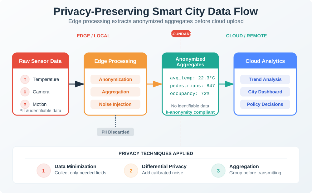
Under the hood, the architecture usually separates field assets, access networks, platform services, department applications, and public release channels. Field assets need signed firmware, secure boot where available, unique device identity, tamper detection for exposed hardware, and a decommissioning process that removes credentials. Access networks need segmentation between operational systems, public Wi-Fi, vendor maintenance access, and back-office services. Platform services need schema validation, time synchronization, deduplication, retention rules, audit logs, and role-based access control.
- Data-governance boundary: define data owner, steward, schema, quality flag, retention period, open-data release, API rate limit, and exception process for sensitive feeds.
- Cyber boundary: define device identity, certificate rotation, network segmentation, vendor remote access, firmware signing, vulnerability response, and IEC 62443-style zone assumptions for operational systems.
- Privacy boundary: define whether video, Wi-Fi, Bluetooth, license-plate, or app data is anonymous, aggregated, blurred, consented, or prohibited; document signage and public review expectations.
- Operations boundary: define battery replacement, cleaning, calibration, pole access, traffic-control permits, outage handling, seasonal drift, service-desk ownership, and procurement exit rights.
Privacy and security controls should be explicit because public-space sensing can drift from service delivery into surveillance. Aggregation, blurring, edge redaction, deletion windows, public sensor registries, privacy impact assessments, and independent review boards all reduce the chance that “we already have a pole” becomes a reason to add unrelated sensing later. These controls are not separate from engineering: they decide where raw data is processed, who can query it, how long it exists, and whether residents can understand the service.
A smart-city platform is successful when a sensor event can be traced from field asset through network, shared city data model, department workflow, resident-facing service, and measured public outcome without locking the city into one vendor or collecting more data than the service needs. The trace should also show the negative case: what the system does when data quality is poor, when a neighborhood is under-covered, when the network is down, or when the requested data use falls outside the approved purpose.