Location Privacy Boundaries
Location privacy starts with the question a feature is allowed to answer. “Is someone home?”, “did the driver reach stop 17?”, “which room contains the pump?”, and “where is the caller during an emergency?” require different precision, timing, retention, and audiences. A design that stores a continuous coordinate trail for all four questions has crossed the product boundary.
Privacy-preserving location design makes the boundary visible. Users should know when tracking is off, paused, active, coarse, precise, emergency-only, or shared with another person. The interface should also show what happens when operating-system permission changes, such as Android approximate location, iOS Precise Location being disabled, background location being denied, or Bluetooth scanning permission being revoked. 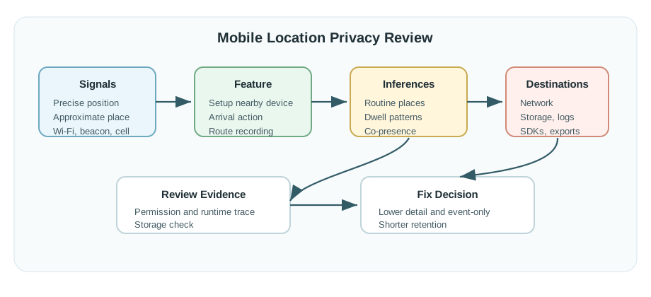
- Purpose: connect each location event to a named feature, not a generic analytics bucket.
- Precision: choose presence, named zone, coarse radius, floor/room, or coordinates according to the task.
- Control: give users pause, delete, export, selective sharing, emergency override, and permission-repair paths they can understand.
That boundary should be stated in product language before the team chooses a sensor. A family safety app might need “arrived at school” and “SOS location now,” not a minute-by-minute route. A workplace comfort system might need “zone occupied” and “zone recently empty,” not a named employee trail. A fleet system might need “stop confirmed,” “break mode active,” and “emergency assistance requested,” not every off-route errand. The privacy design is stronger when the feature can still be explained without showing a raw map.
The user experience should also reveal uncertainty. Approximate permission, stale fixes, indoor drift, multipath, low battery, disabled Bluetooth, revoked background access, and missing network connectivity can all change what the system knows. Instead of quietly escalating collection, the interface can show “using coarse arrival zone,” “waiting for local geofence,” “precise location shared for emergency only,” or “tracking paused until the next shift.” Those visible states help users understand the tradeoff and help operators avoid over-trusting a location claim.
Finally, location privacy includes people who are not the account owner. Children, guests, employees, delivery drivers, patients, bystanders, and nearby device owners can appear in location-derived data. The design record should name who is sensed, who controls the setting, who can see the result, and how a person can challenge or delete a record. Without that record, later analytics, support tooling, or partner integrations can turn a narrow feature into broader surveillance. ## Data Flow Before Maps {.depth-l1}
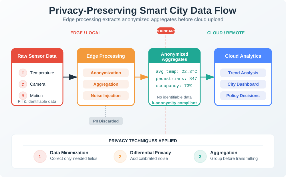
Start by drawing where raw location appears and where it disappears. A phone can evaluate a geofence locally through Android Geofencing API, Google Fused Location Provider, Apple Core Location region monitoring, or the browser Geolocation API. A wearable can convert GNSS, BLE proximity, UWB room state, or Wi-Fi BSSID observations into a zone event before upload. A building system can store occupancy counts from PIR, CO2, or mmWave presence sensors without naming individuals.
The server should receive the least precise event that still runs the feature. For many automations, that means “entered home geofence,” “asset near dock 3,” “room occupied,” or “driver arrived at stop 17” rather than raw latitude/longitude. When precise location is justified, such as SOS, fall detection, E911-like emergency escalation, or turn-by-turn navigation, shorten retention and mark the event with the reason precision was used.
- Define the event schema: include purpose, precision tier, source, timestamp, freshness, consent version, retention expiry, and sharing audience.
- Separate modes: handle off-duty, break, guest, child, caregiver, employee, emergency, and support states with different defaults.
- Test the controls: verify denied permission, approximate permission, pause, deletion, export, background tracking, emergency sharing, and retention expiry.
Design the permission flow as a recovery path, not only an onboarding step. The app should explain why foreground location, background location, Bluetooth scanning, nearby-device access, notification permission, or motion activity is requested, and it should still offer a degraded feature when the user declines. For example, a thermostat can accept manual “away” status, a child tracker can show the last known zone with staleness, and a delivery app can request a one-time precise fix only at delivery confirmation. A privacy review should include screenshots or test notes for each denied, approximate, paused, and restored state.
Then align operational dashboards with the same precision tiers. Dispatchers, caregivers, supervisors, support agents, and analytics users rarely need identical views. A dispatcher may need live location for an active incident, a caregiver may need a safe-zone alert, a supervisor may need aggregate on-shift progress, and support may only need permission state and error logs. If every role receives a full coordinate history because it was convenient to build one map component, the product has failed the minimization design.
Before release, walk one event through the system. Take “entered delivery stop” from GNSS or fused provider, through local geofence evaluation, event creation, upload, API validation, database storage, dashboard display, export, retention expiry, and deletion. Confirm that the record keeps the purpose id, precision tier, consent version, and expiry date, and confirm that raw coordinates are absent when the feature promised zone-only processing. This walkthrough catches privacy regressions that a UI review alone misses. ## Minimize Before Persisting {.depth-l2}
Location systems need minimization at the edge, in transit, and at rest. On the device, convert coordinates to geofence transitions or room/zone labels when possible. In transit, use TLS and avoid query-string coordinates. At rest, separate identity from location events, apply role-based access control, encrypt sensitive fields, set retention TTLs, and log access to live or historical location.
Be careful with identifiers that look harmless. Bluetooth LE identifiers, Wi-Fi BSSID lists, device ids, advertising ids, installation ids, and repeated timestamps can re-identify a person even when a name is removed. Aggregation needs suppression thresholds or differential privacy noise when outputs are shared beyond the immediate operational team. Support tools should show only the precision needed for the support task.
- Derived event: prefer zone_enter, zone_exit, near_beacon, room_occupied, stop_confirmed, or emergency_location over raw coordinate streams.
- Access boundary: separate user view, caregiver view, dispatcher view, support view, and analytics view so one role does not inherit every location detail.
- Failure mode: when permission is denied, sensors disagree, or the event is stale, explain the degraded behavior without pushing users into unnecessary tracking.
Implementation should treat privacy as data-plane behavior. A mobile client can keep raw latitude and longitude in memory long enough to evaluate a geofence, then upload only a signed zone transition with a monotonic event id. A gateway can translate room-level UWB or BLE observations into an occupancy topic before publishing to MQTT. An API can reject coordinate fields on endpoints that accept only zone events. A database can place precise emergency records in a short-retention table instead of the same table used for routine analytics.
Schema design matters. Useful fields include event_id, user_or_device pseudonym, purpose_id, precision_tier, source_family, zone_id, timestamp, observed_at, received_at, stale_after, consent_version, retention_until, emergency_flag, and sharing_scope. Store quality and policy metadata alongside the derived event so later services do not infer permission from missing fields. If the product supports export or deletion, keep enough indexing to find all records for the user without joining through a raw coordinate trail.
Security controls should match the sensitivity of location history. Enforce authorization on both live and historical reads, protect admin dashboards with least-privilege roles, log access to precise or emergency events, and alert on bulk exports or unusual support lookups. Encrypting a coordinate column is helpful, but it does not solve purpose creep if analytics jobs, feature stores, or partner webhooks receive the same precise data. The safer pattern is to minimize first, then encrypt, audit, and expire the records that remain.
Automated tests can keep the contract honest. Add fixtures for denied permission, approximate permission, background revocation, emergency escalation, retention expiry, support access, and deletion. The assertions should check not only that the feature works, but that forbidden data is absent: no coordinates in zone-only events, no user id in aggregate occupancy, no retained emergency fix after the retention window, and no support view of precise history without an authorized purpose.
- You now know how to state the location question a feature is allowed to answer.
- You now know why raw coordinates should disappear into zone, room, stop, or emergency events as early as possible.
- You now know how purpose ids, precision tiers, retention expiry, and role views keep minimization enforceable.
We have bounded what the product is allowed to know. The next question is how a release review turns those boundaries into practical privacy patterns and user controls.

 Checkpoint: Boundary and Data Flow