Location is not just a dot on a map; it is evidence for a decision. Start with the action location enables, the accuracy and freshness it needs, the privacy boundary it crosses, and the fallback message when the system is uncertain.
32.2 Summary
Location awareness gives IoT systems context for automation, safety, navigation, asset tracking, and resource management. Effective designs match positioning technology to environment, accuracy, power, infrastructure, and privacy requirements.
Phoebe’s Field Notes: Where the Path-Loss Exponent n Actually Comes From
Phoebe’s Why
This chapter already gives the working formula for BLE ranging, \(\mathrm{RSSI}=-10n\log_{10}(d)+A\), and its own worked numbers show why a 4 dB measurement error becomes about a 2.3 m distance error at 5 m range. What that formula does not show is where the \(n=2\) baseline comes from, or why obstacles push \(n\) higher. It comes from the same spherical-spreading argument that sets GPS’s very different error budget: an isotropic transmitter spreads power over a growing sphere, so received power falls as the inverse square of distance in free space – exactly \(n=2\). Real indoor paths are not free space, so \(n\) becomes an empirically fitted exponent that absorbs walls, floors, and multipath into a single number, which is exactly why this chapter is right to treat the resulting metres as a calibrated estimate rather than a ruler reading.
The Derivation
Power density from spherical spreading, and free-space received power:
Worked Numbers: This Chapter’s Own BLE and GPS Claims
Where free-space \(n=2\) comes from, at BLE’s own 2.4 GHz, \(d_0=1\) m:\(\mathrm{FSPL}(1\text{m})=20\log_{10}(1)+20\log_{10}(2.4\times10^9)-147.55=40.1\) dB, so an idealised isotropic 0 dBm beacon would read about \(-40.1\) dBm at 1 m.
The gap that calibration is really absorbing: a catalog-typical BLE reference constant \(A=-59\) dBm at 1 m sits \(40.1-59.0=18.9\) dB below the idealised Friis prediction – that 18.9 dB is antenna mismatch, chip-antenna inefficiency, and body/enclosure loss folded into the single number \(A\), not a measurement of free space at all.
Reproducing this chapter’s own error claim (its own \(n=2\), \(\Delta\mathrm{RSSI}=4\) dB): \(\Delta d/d=\ln(10)\times4/(10\times2)=0.461\), so at \(d=5\) m the distance error is \(0.461\times5=2.30\) m – matches this chapter’s own stated “error \(\approx\) 2.3 m” exactly.
Fade margin for one obstacle plus reliability (catalog-typical single interior wall \(\approx8\) dB, catalog-typical multipath-reliability allowance \(\approx12\) dB for about 90% link success): \(8+12=20.0\) dB of margin a design should budget above the nominal path loss.
What buying that margin costs the battery: raising beacon transmit power by 6 dB to buy back fade margin multiplies radiated power by \(10^{6/10}=3.98\times\), and with it the energy spent per advertisement – the same coin-cell energy budget this module’s Connected Devices Fundamentals chapter derives in full, so every extra decibel of range or reliability is a specific, non-free draw against that budget, not a firmware setting with no physical cost.
Chapter Roadmap
This chapter moves from design intent to implementation guardrails.
First you define the location decision, confidence state, consent boundary, and fallback message.
Then you compare outdoor, indoor, proximity, cellular, inertial, and fused signals against risk and place.
Next you test geofence timing, accuracy, infrastructure cost, privacy, and battery consequences.
Finally you use the quizzes and exercises to check whether the system stays honest when location is uncertain.
Checkpoint callouts mark the main pacing stops. Deep-dive calculators and examples are references you can revisit after the first read.
32.3 Learning Objectives
By the end of this chapter, you will be able to:
Explain Location Awareness: Describe why location awareness is fundamental to IoT and mobile services
Compare Positioning Technologies: Evaluate GPS, Wi-Fi, BLE beacons, UWB, and cellular positioning for different scenarios
Classify Application Domains: Distinguish where location-aware systems add value (safety, energy, navigation, social)
Assess Technology Trade-offs: Analyze accuracy, cost, power, and infrastructure trade-offs for positioning systems
32.4 Prerequisites
Before diving into this chapter, you should be familiar with:
Wireless Communication Fundamentals: Understanding of RF propagation, signal strength, and time-of-flight principles is essential for grasping positioning technologies
Sensor Fundamentals: Knowledge of how sensors work provides context for understanding GPS receivers, accelerometers, and other positioning sensors
32.5 Location as Design Signal
Location awareness helps an IoT system decide what context it is in: at home or away, inside or outside, near a machine or outside the safe zone, on the correct shelf or only in the correct building. The useful design question is what action changes when location confidence changes.
A precise coordinate is not always the right target. A thermostat may only need home/away presence. A hospital asset tag may need room-level location. A warehouse robot may need lane-level position and obstacle context. A safety application may need a conservative geofence that avoids false unlocks, false alarms, or missed exits.
Figure 32.1: Location-aware products should select positioning methods from the decision they support, the operating environment, the acceptable error, and the infrastructure the team can maintain.
The same raw location estimate can support very different product behavior. A home automation app may use “inside the home geofence” as a low-risk hint to warm the house, but it should not use the same hint to unlock a door without additional confirmation. A delivery app can show “nearby” when GPS uncertainty is high, while a warehouse forklift system may need lane-level confidence before changing a speed rule. The interface should communicate the level of confidence that matters to the next action.
That is why location awareness is a service design problem as much as a sensing problem. The product has to define the zones people understand, the automation that depends on each zone, the fallback when location is stale, and the privacy promise attached to the data. Users rarely think in latitude and longitude. They think in places, routes, rooms, entrances, shelves, restricted areas, and “close enough to act.” A good system translates signals into those terms without hiding uncertainty.
The beginner mistake is treating location as a single answer. Real systems usually have a location claim with a source, age, estimated error, confidence, and permission state. A location claim can be fresh but coarse, precise but stale, available outdoors but missing indoors, or accurate for the device while still wrong for the person carrying it. The design should name those states before using location to automate anything important.
Outcome: Name the decision location should support: alert, unlock, route, log, disable, hand over, or ask for confirmation.
Confidence: Define what the system does when position is fresh, stale, approximate, contradictory, or unavailable.
Consent: Explain what is collected, when it is collected, who can see it, and how long it remains useful.
32.6 Match Tech to Risk and Place
Choose positioning technology from the operating context, not from the most accurate option on paper. GNSS works well outdoors but degrades indoors, in urban canyons, and near reflective surfaces. Wi-Fi positioning can reuse installed access points but depends on fingerprint quality and infrastructure change. BLE beacons are cheap for proximity but RSSI moves with bodies, shelves, and doors. UWB can support precise ranging but needs anchors, calibration, and power planning.
Cellular positioning, LTE-M, NB-IoT, LoRaWAN gateway metadata, inertial sensors, barometers, QR codes, NFC tags, and manual check-in can also be useful when the product needs coarse zones, audit-friendly check points, or fallback confirmation. Many real systems fuse several weak signals instead of trusting one perfect source.
Start by writing an accuracy budget in product language. For a hospital asset tag, “the correct room within a few meters” may be enough because staff only need to find the wheelchair or pump. For a worker safety exclusion zone, a false “outside the danger zone” result can injure someone, so the design may need conservative boundaries, dwell time, redundant signals, and a local alarm. For a parking reminder, a coarse estimate may be acceptable if the app shows uncertainty and lets the user correct it.
Then design the zone model. A zone can be a country, site, building, floor, room, corridor, shelf, doorway, dock bay, vehicle, or near-device bubble. Each zone needs an enter rule, exit rule, stale limit, and ownership model. Geofences often need hysteresis so the enter boundary is not the same as the exit boundary. Indoor systems often need map versioning because moving a beacon, anchor, access point, or metal shelving can change the signal landscape.
Finally, plan field maintenance and privacy before rollout. BLE tags need battery replacement and attachment policy. UWB anchors need surveyed locations and clock behavior. Wi-Fi fingerprints need refresh when access points move. Smartphone location needs operating-system permission flows, background limits, and battery-aware scan intervals. Privacy review needs to decide whether exact paths are required, whether coarse zones are enough, and who can access historic movement records.
Set the zone model. Decide whether the product needs country, site, building, floor, room, shelf, lane, doorway, or near-device context.
Set the error policy. Define hysteresis, dwell time, confidence threshold, and manual confirmation for risky transitions.
Set the maintenance model. Include beacon batteries, UWB anchor placement, map updates, calibration, access-point moves, and privacy review.
Checkpoint: Fit the Zone
You now know:
A useful location design starts with the action it changes, not with the sensor brand.
Zones need enter rules, exit rules, stale limits, ownership, and maintenance plans.
Privacy review belongs beside the accuracy budget because coarse zones are often enough.
32.7 Location Needs Time and Frames
Location data is only meaningful with a coordinate frame, timestamp, source, and quality estimate. A latitude/longitude pair from GNSS, a room label from BLE fingerprinting, and a distance estimate from UWB two-way ranging are different kinds of claims. They should not be mixed without stating uncertainty.
Reliable location-aware systems also model transitions. Geofences need enter and exit thresholds, dwell time, and duplicate suppression. Indoor systems need map versioning, anchor identity, clock behavior, and multipath handling. Mobile apps need permission state, background execution limits, battery policy, and local fallback when the operating system throttles scans.
GNSS estimates position from satellite timing and needs line of sight to enough satellites. Urban canyons and indoor spaces introduce multipath, where reflected signals make the receiver solve against a distorted path length. Wi-Fi and BLE methods often use received signal strength or fingerprints, so walls, people, doors, and shelving can change the estimate. UWB improves ranging by using very short pulses and time-of-flight or time-difference methods, but it depends on anchor geometry, calibration, and clock assumptions.
Sensor fusion is useful because each signal fails differently. A phone can combine GNSS, Wi-Fi scans, Bluetooth scans, inertial motion, barometer readings, cellular information, and map constraints. An industrial RTLS can combine UWB anchors with BLE proximity or manual check points. The fusion layer should output more than a position: it should include source list, confidence, estimated error, last update time, coordinate frame, and whether the value is suitable for automation or only for display.
Automation should consume those quality flags deliberately. A stale room estimate might still be useful for search history but not for a live safety alert. A geofence transition might require 30-60 seconds of dwell time before an arrival action fires. A high-risk unlock or machine-control rule might require a second factor such as local BLE proximity, NFC tap, keypad input, or operator confirmation. Those policies belong in the product contract, not as hidden thresholds scattered through code.
Quality: Store source, timestamp, estimated error, stale limit, and confidence so automation can degrade safely.
Fusion: Combine GNSS, Wi-Fi, BLE, UWB, inertial, cellular, and manual signals only when their coordinate frames and timing are understood.
Privacy: Prefer coarse zones, on-device checks, short retention, aggregation, and explicit user controls when exact paths are not needed.
32.8 Getting Started (For Beginners)
Location Awareness Basics
Analogy: Location awareness is like giving your IoT devices a sense of where they are.
Just like you know you’re in the kitchen (not the bedroom), IoT devices can learn their location and act differently based on it!
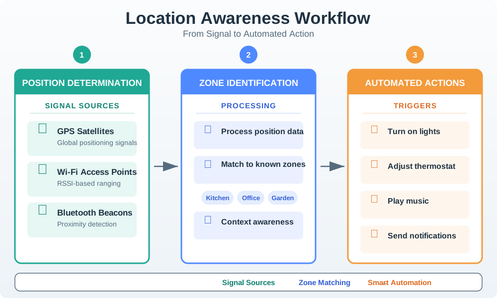
Figure 32.2: Diagram showing location awareness workflow: device determines its position using GPS/Wi-Fi/Bluetooth signals, position data is processed to identify the zone, and automated actions are triggered based on location.
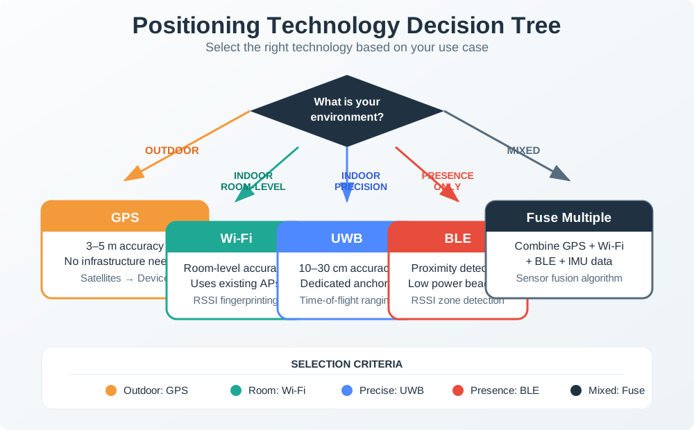
Positioning Tech Decision Tree
This decision tree helps you choose the right positioning technology based on environment, accuracy requirements, and infrastructure constraints.
Figure 32.3: Technology selection guide: Outdoor-only with 3-5m accuracy? Use GPS (no infrastructure). Need sub-meter outdoor? Add RTK corrections. Indoor room-level? Wi-Fi fingerprinting reuses existing infrastructure. Indoor precision? Deploy UWB anchors. Just presence detection? BLE beacons are cheapest. Mixed environments? Fuse multiple technologies like smartphones do.
How Do Devices Know Where They Are?
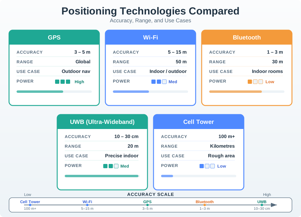
Different technologies for different needs:
Technology
How It Works
Accuracy
Best For
GPS
Satellites in space
3-5 meters
Outdoors
Wi-Fi
Known router locations
5-15 meters
Indoors/outdoors
Bluetooth Beacons
Small transmitters
1-3 meters
Indoor rooms
UWB
Ultra-precise timing
10-30 cm
Exact position
Cell Tower
Phone network
100+ meters
Rough area
Figure 32.4: Chart comparing positioning technologies by accuracy and use case.
Key Concept: Geofencing
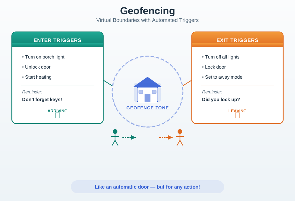
What is it? An invisible “fence” around a location that triggers actions when crossed.
Analogy: Like an automatic door that opens when you approach—but for any action!
Enter Geofence
Exit Geofence
Turn on porch light
Turn off all lights
Unlock door
Lock door
Start heating
Set to away mode
Reminder: “Don’t forget keys!”
Reminder: “Did you lock up?”
Figure 32.5: Diagram illustrating geofencing: a virtual boundary around a home location with automated triggers when user enters or exits.
Privacy Matters!
Location data is sensitive. Your position reveals: - Where you live and work - What stores you visit - When you’re not home
Best Practices:
Only collect location when needed
Let users control tracking
Store location data securely
Delete old location history
Self-Check Questions
Before diving deeper, test your understanding:
Why would GPS not work well inside a building?
Hint: Where are the satellites?
What’s the difference between GPS (5m accuracy) and UWB (10cm)?
Hint: One tells you the street, the other tells you the shelf
What is a geofence?
Hint: An invisible boundary that triggers actions
Answers explored in the detailed chapters!
Positioning Accuracy Tradeoffs
Different technologies achieve different accuracy levels through fundamental physics constraints:
GPS (outdoor):
Satellite signal travels at speed of light: \(c = 3 \times 10^8\) m/s
Timing precision: ~10 ns (commercial receivers)
Distance error: \(\Delta d = c \times \Delta t = 3 \times 10^8 \times 10 \times 10^{-9} = 3\) m
With 4 satellites and geometric dilution of precision (GDOP ≈ 1.5), typical accuracy: \[\sigma_{\text{pos}} = \text{GDOP} \times \sigma_{\text{range}} \approx 1.5 \times 3 = 4.5 \text{ m}\]
BLE beacons (indoor):
RSSI-based ranging: \(\text{RSSI} = -10n \log_{10}(d) + A\) where \(n \approx 2\) (path loss exponent), \(A =\) signal at 1m
Multipath fading adds ±4 dB variance
Distance uncertainty: \(\Delta d = d \times \ln(10) \times \frac{\Delta \text{RSSI}}{10n} \approx 0.46d\) (for 4 dB error)
At 5 m distance, error ≈ 2.3 m; trilateration with 3 beacons yields ~3-5 m accuracy
A location claim should carry source, age, estimated error, confidence, permission state, and coordinate frame.
GPS, Wi-Fi, BLE, UWB, cellular, inertial, and manual signals fail in different ways, so fusion must expose uncertainty.
Automation should degrade from control to display, history, or confirmation when the quality flags are not strong enough.
For Kids: Meet the Sensor Squad!
Location Awareness is like having a magic treasure map that always knows where you are!
Imagine you have a special map that follows you wherever you go. When you walk into the kitchen, the map lights up and says “Kitchen!” When you go outside to play, it says “Backyard!” Smart devices use this same idea to know where they are and do helpful things automatically.
32.8.2 Great Treasure Hunt
It was Grandpa’s birthday, and the Sensor Squad had planned the most amazing treasure hunt ever! But there was a problem - how would Grandpa know where to go next?
“I know!” said Sammy the Sensor. “We can use LOCATION AWARENESS! I’ll put little helper sensors all around the house and yard.”
Lila the LED placed tiny Bluetooth beacons everywhere - one in the kitchen, one in the garage, one by the big oak tree, and one in the garden shed. Max the Microcontroller programmed Grandpa’s special treasure hunt tablet to know about each beacon.
“Now watch this,” whispered Bella the Battery excitedly.
Grandpa picked up the tablet and saw: “Start at the kitchen table!” He walked to the kitchen, and the tablet beeped. “You found Clue 1! Now go where we keep the car.”
“The garage!” laughed Grandpa. As he walked toward the garage, the tablet knew exactly when he arrived and showed the next clue.
But the coolest part happened when Grandpa got to the big oak tree. “It’s too far for the beacons,” worried Lila. “What do we do?”
“GPS to the rescue!” announced Sammy. “When we’re outside, we can use satellites in SPACE to find our location!” The tablet switched from using the indoor beacons to using GPS signals from satellites orbiting Earth.
Grandpa found all the clues and his present - a new garden tool kit! “How did it always know where I was?” he asked in amazement.
The Sensor Squad smiled. They had learned that different location tools work in different places: GPS works outside, beacons work inside, and smart devices can switch between them automatically!
32.8.3 Key Words for Kids
Word
What It Means
GPS
A system using satellites in space to find where you are outdoors (like a treasure hunt clue from space!)
Bluetooth Beacon
A tiny device that says “I’m here!” to phones and tablets nearby (like a lighthouse for indoor navigation)
Geofence
An invisible fence around a place that triggers actions when you cross it (like a magic doormat)
Trilateration
Measuring distances from multiple known points to figure out where you are (like Marco Polo but with math!)
32.8.4 Try This at Home!
The Human GPS Game
This game shows how GPS uses multiple satellites to find your location!
Go to a room and stand somewhere (this is the “mystery location”)
Have 3 friends or family members stand in different corners of the room
Each person measures how many “giant steps” away you are from them and says it out loud:
Person A: “5 steps from me!”
Person B: “3 steps from me!”
Person C: “4 steps from me!”
Now have someone who wasn’t watching try to find your mystery location using ONLY those step counts
They should be able to find the ONE spot that matches all three distances!
This is exactly how GPS works - satellites in space measure how far you are, and by using 3 or more distances, they find the one spot where you must be. Try moving to different spots and see if your “human satellites” can always find you!
Key Concepts
IoT Device Architecture: Hardware stack comprising microcontroller, sensors, connectivity module, power supply, and optional display or actuator.
Design Triangle: Trade-off between size, battery life, and capability that constrains every IoT device design decision.
Power Budget: Maximum average current consumption a device can draw while meeting its battery life target.
Form Factor: Physical size, shape, and mounting method of a device determined by its deployment environment and user interaction model.
Ingress Protection (IP) Rating: IEC 60529 code specifying a device’s resistance to dust and water ingress, required for outdoor and industrial deployments.
Bill of Materials (BOM): Itemised list of every component in a device with part numbers, quantities, and costs used for procurement and cost estimation.
Certification: Regulatory approval (FCC, CE, UL) required before a wireless IoT device can be sold in a given market.
32.9 Introduction
Location Awareness: The ability of a system to determine and utilize the physical position of devices, users, or objects in space.
Device mobility is fundamentally about moving through space, so localisation is at the core of many mobile services and applications.
32.9.1 Why Location Matters
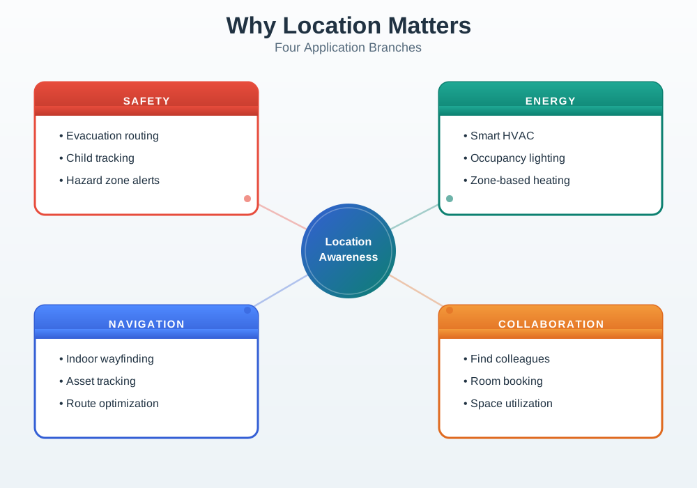
Figure 32.6: Mindmap showing location awareness at center with four main application branches.
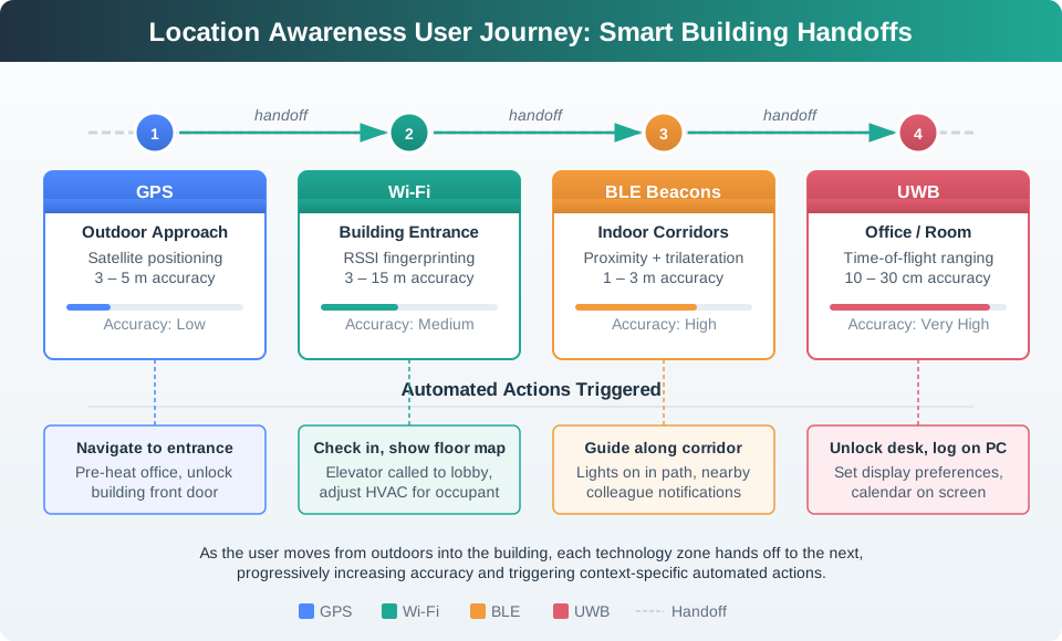
Figure 32.7: Location Awareness User Journey: Following a person through a smart building showing technology handoffs (GPS to Wi-Fi to BLE to UWB) and automated actions triggered at each stage.
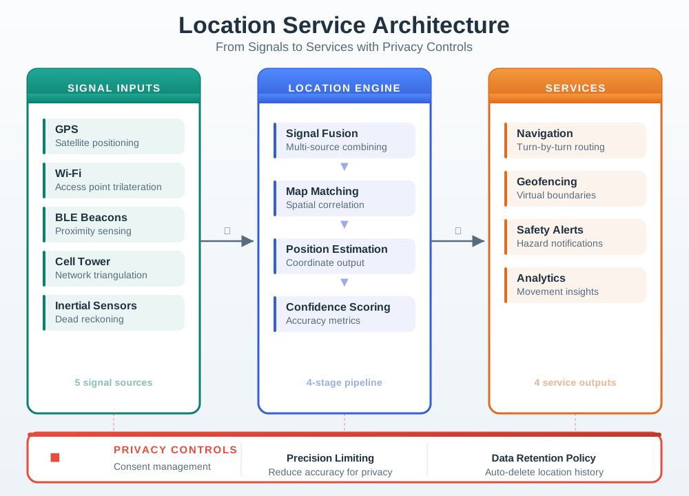
32.9.2 High-Level Location Service Architecture
Figure 32.8: Architecture diagram showing location service components with privacy controls.
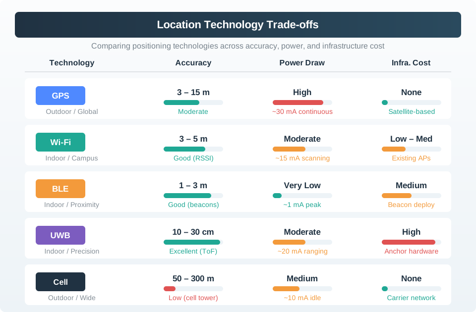
Figure 32.9: Location Technology Trade-offs: Comparing positioning technologies across accuracy, power consumption, and infrastructure cost dimensions.
This architecture highlights key ideas:
Multiple technologies (GPS, Wi-Fi, BLE, cell, inertial sensors) contribute signals; no single method is perfect in all environments.
A location engine fuses these signals with map/context data to produce a best-estimate position rather than trusting one raw source.
Applications consume location through stable services (navigation, safety, geofencing, analytics) instead of re-implementing algorithms.
Privacy controls (consent, precision, retention) must surround both the engine and services—location is powerful but highly sensitive data.
Retail: Find the right item, intelligent shopping, personalized offers
Health: Activity level monitoring, care of elderly, patient tracking
MVU: Context Detection and Geofencing
Core Concept: Context-aware systems detect user situation (location, time, activity, social setting) through sensor fusion and use this information to adapt behavior automatically, eliminating manual configuration and explicit commands. Why It Matters: Users expect smart devices to be actually smart - anticipating needs rather than requiring constant input. Geofencing (triggering actions when crossing virtual boundaries) enables powerful automations like “unlock door when I arrive home” that make IoT invisible and valuable. Key Takeaway: Geofence triggers should use 100-150 meter radius for reliable home/away detection (accounting for GPS accuracy of 5-15m), with 30-60 second dwell time to prevent false triggers from driving past. Privacy requires explicit user consent and local-first processing where possible.
Key Takeaway
In one sentence: Devices should adapt to situation (location, time, activity) automatically - explicit configuration is a UX failure.
Remember this rule: The best interface is no interface - if users have to manually tell the system where they are, you’ve failed at context-awareness.
This Python class implements circular geofencing with dwell-time filtering, the core pattern behind smart home automations like “turn on lights when I arrive home.” The dwell-time requirement prevents false triggers from driving past a location:
import mathimport timeclass GeofenceEngine:"""Circular geofence with dwell-time to prevent false triggers. Uses the Haversine formula for GPS distance calculation and requires the device to remain inside/outside the fence for a minimum dwell period before firing the trigger. """def__init__(self):self.fences = {}self.state = {} # fence_name -> {inside, entered_at}def add_fence(self, name, lat, lon, radius_m, dwell_sec=30):"""Register a circular geofence. Args: name: Fence identifier (e.g., "home"). lat, lon: Center coordinates in decimal degrees. radius_m: Fence radius in meters (100-150m recommended for GPS to avoid false triggers). dwell_sec: Minimum seconds inside/outside before trigger. """self.fences[name] = {"lat": lat, "lon": lon,"radius": radius_m, "dwell": dwell_sec }self.state[name] = {"inside": False, "changed_at": 0}def _haversine_m(self, lat1, lon1, lat2, lon2):"""Calculate distance between two GPS points in meters.""" R =6371000# Earth radius in meters phi1, phi2 = math.radians(lat1), math.radians(lat2) dphi = math.radians(lat2 - lat1) dlam = math.radians(lon2 - lon1) a = (math.sin(dphi /2) **2+ math.cos(phi1) * math.cos(phi2) * math.sin(dlam /2) **2)return R *2* math.atan2(math.sqrt(a), math.sqrt(1- a))def update(self, lat, lon, timestamp=None):"""Process a GPS fix and return any triggered events. Args: lat, lon: Current device position. timestamp: Unix timestamp (defaults to now). Returns: List of (fence_name, event_type) tuples where event_type is "enter" or "exit". """if timestamp isNone: timestamp = time.time() events = []for name, fence inself.fences.items(): dist =self._haversine_m(lat, lon, fence["lat"], fence["lon"]) currently_inside = dist <= fence["radius"] state =self.state[name]if currently_inside != state["inside"]:# Position changed -- start dwell timerif state["changed_at"] ==0: state["changed_at"] = timestampelif timestamp - state["changed_at"] >= fence["dwell"]:# Dwell time met -- confirm transition event ="enter"if currently_inside else"exit" events.append((name, event)) state["inside"] = currently_inside state["changed_at"] =0else: state["changed_at"] =0# Reset if bounced backreturn events# Usage: Smart home automationengine = GeofenceEngine()engine.add_fence("home", lat=51.5074, lon=-0.1278, radius_m=120, dwell_sec=30)engine.add_fence("office", lat=51.5155, lon=-0.1419, radius_m=150, dwell_sec=60)# Simulate arriving home (30+ seconds inside fence)events = engine.update(51.5075, -0.1279, timestamp=1000)# No events yet (dwell timer started)events = engine.update(51.5074, -0.1277, timestamp=1035)# Returns: [("home", "enter")] after 35 seconds inside
Design decisions for reliable geofencing:
Parameter
Recommended
Why
Radius
100-150m
GPS accuracy is 5-15m; smaller fences cause flapping
Dwell time
30-60 seconds
Prevents false triggers from driving past
Update rate
Every 10-30 seconds
Balances battery life with responsiveness
Hysteresis
20% of radius
Exit fence is larger than entry fence to prevent oscillation
The next design question is whether the chosen accuracy tier is worth its installation and operating cost.
32.11 Indoor Positioning Cost Tradeoffs
One of the most common mistakes in location-aware IoT projects is over-specifying accuracy. A hospital that needs to know which room a wheelchair is in (3-meter accuracy) does not need centimeter-precise UWB tracking. The cost difference is dramatic.
Real-world deployment cost comparison for a 10,000 m2 building (e.g., a hospital floor):
Technology
Infrastructure Cost
Per-Tag Cost
Accuracy
Battery Life
Total for 200 Tags
BLE Beacons (proximity)
$3,000 (50 beacons at $60)
$8-15 per tag
3-5 meters (room-level)
2-4 years
$4,600-6,000
Wi-Fi Fingerprinting
$0 (uses existing APs)
$0 (uses existing devices)
5-15 meters (zone-level)
N/A (device battery)
$2,000 (calibration labor)
BLE AoA (Angle of Arrival)
$15,000 (30 locators at $500)
$8-15 per tag
0.5-1 meter
1-2 years
$16,600-18,000
UWB (Ultra-wideband)
$40,000 (80 anchors at $500)
$25-50 per tag
10-30 cm
6-12 months
$45,000-50,000
Camera-based (RTLS)
$60,000 (40 cameras at $1,500)
$0 (no tags)
30-50 cm
N/A
$65,000+ (plus privacy issues)
Decision framework – match accuracy to actual need:
Use Case
Required Accuracy
Recommended Technology
Why
Asset tracking (which room?)
3-5 meters
BLE proximity beacons
Cheapest, longest battery life, room-level is sufficient
Retail analytics (which aisle?)
2-3 meters
BLE zone detection
Customers already carry phones with BLE
Warehouse picking (which shelf?)
0.5-1 meter
BLE AoA or UWB
Need aisle-level precision; BLE AoA is 3x cheaper than UWB
Manufacturing assembly (exact position)
10-30 cm
UWB
Only UWB delivers sub-meter reliably indoors
Sports analytics (player tracking)
10-30 cm, 10 Hz
UWB
Needs both accuracy AND high update rate
Elderly care (fall detection + location)
Room-level + motion
BLE + accelerometer
Accuracy matters less than battery life and comfort
The 80/20 rule for indoor positioning: 80% of indoor location use cases are satisfied by room-level accuracy (3-5 meters). Only 20% truly need sub-meter precision. Starting with BLE beacons at $4,600 and upgrading later if needed is almost always better than deploying $50,000 UWB infrastructure and discovering that room-level was sufficient.
Hidden costs to budget for:
Cost Category
BLE Beacons
UWB
Infrastructure hardware
$3,000
$40,000
Site survey and calibration
$1,500 (1 day)
$8,000 (3-5 days)
Beacon/anchor battery replacement (annual)
$500/year
$3,000/year
Software platform license
$2,000-5,000/year
$10,000-25,000/year
3-year total cost of ownership
$10,500-19,500
$70,000-115,000
The 3-year TCO difference between BLE and UWB can be 5-7x. For a hospital with 200 tracked assets, that means spending $55 per asset per year (BLE) versus $350 per asset per year (UWB). Choose the accuracy your application actually needs, not the accuracy that sounds impressive in a vendor demo.
Geofencing Needs Dwell Time
What Practitioners Do Wrong: Implementing geofence triggers that fire immediately when a device crosses the virtual boundary, without requiring the device to remain inside/outside for a minimum duration (dwell time).
The Problem: GPS accuracy is 5-15 meters in typical conditions, and can degrade to 20-50 meters in urban canyons (buildings causing multipath interference). Without dwell time, normal GPS noise causes constant fence crossing events as the reported location bounces around the boundary.
Real-World Example: A smart home company deployed geofencing with a 100m radius and zero dwell time for 10,000 users. After 2 weeks:
Issue
Frequency
User Impact
False “arrived home”
14.2 per user/week
Lights/HVAC turning on when driving past house
False “left home”
8.7 per user/week
Security armed while checking mail outdoors
Rapid oscillation
23% of users experienced >5 enter/exit cycles in 10 minutes
Lights flickering on/off, thermostats cycling
User response
41% disabled geofence automation entirely
Feature abandoned due to unreliability
Support tickets
18,000 tickets in 2 weeks
“Automation is broken” complaints
Why It Failed:
GPS drift: Stationary device reports location wandering 10-30m due to satellite geometry changes
Driving past: User drives past home on highway 150m away, GPS error puts them “inside” fence for 5 seconds
Brief outdoor trips: User steps outside for 2 minutes (get mail, take trash out), triggers “left home”
The Correct Implementation (With Dwell Time):
# BAD: No dwell timeif distance < fence_radius: trigger_arrived_home() # Fires on any GPS spike inside fence# GOOD: 30-second enter dwell, 45-second exit dwellif distance < fence_radius:ifnot currently_inside: start_dwell_timer('enter', 30) # Must stay inside for 30selif dwell_timer_expired('enter'): trigger_arrived_home() # Only fires after 30s insideelse:if currently_inside: start_dwell_timer('exit', 45) # Must stay outside for 45selif dwell_timer_expired('exit'): trigger_left_home() # Only fires after 45s outside
Recommended Dwell Time Parameters:
Fence Purpose
Radius
Enter Dwell
Exit Dwell
Rationale
Home automation
100-150m
30-60s
45-90s
Longer exit dwell prevents false exits from outdoor tasks
Retail geofence (coupon delivery)
50-100m
10-20s
10-20s
Shorter dwell OK for low-stakes actions
Security system arming
150-200m
60s
120s
Conservative dwells for safety-critical function
Fleet “arrived at site”
30-50m
30s
15s
Smaller radius (site-specific), longer enter dwell to confirm arrival
Measured Impact of Adding Dwell Time:
Metric
No Dwell Time
30s Enter / 45s Exit Dwell
Improvement
False positive rate
14.2 per week
0.4 per week
97% reduction
User satisfaction
2.3/5
4.1/5
+78%
Automation retention
59% (41% disabled)
96% (4% disabled)
+63%
Support tickets
18,000 in 2 weeks
180 in 2 weeks
99% reduction
Key Lesson: Geofence automation without dwell time is broken by design. Always require 30-60 second dwell before triggering “arrived” and 45-120 second dwell before “departed.” GPS noise is not a bug—it’s a fundamental characteristic that must be designed around.
Checkpoint: Tune the Fence
You now know:
GPS accuracy of 5-15 meters makes immediate geofence triggers unreliable near boundaries.
Home automation usually needs a 100-150 meter radius plus 30-60 second enter dwell and longer exit dwell.
Field testing should measure false arrivals, false departures, battery impact, support load, and user disablement.
This chapter covers location awareness fundamentals, explaining the core concepts, practical design decisions, and common pitfalls that IoT practitioners need to build effective, reliable connected systems.
Try It Yourself
Hands-on exercises to explore location awareness:
32.12.1 Exercise 1: Build a Simple Geofence
Use smartphone location services:
Define home geofence: Center at your address, radius 150 meters
Implement on-device detection (IFTTT, Tasker, or Shortcuts app)
Trigger: “Send notification when entering/exiting home zone”
Test by walking around neighborhood, crossing boundary multiple times
What to observe: Count false triggers when walking past house without entering. Notice dwell time needed to prevent false alarms (30-60 seconds typical). Measure GPS accuracy variation (5-20m depending on sky view).
32.12.2 Compare Indoor Accuracy
Visit a large building with Wi-Fi and walk a known path:
Use Wi-Fi-based location app (Google Maps indoors, if available)
Record estimated positions every 10 meters along your path
Compare to actual positions measured on building floor plan
Calculate average error
What to observe: Wi-Fi typically gives 5-15m accuracy indoors. Notice how accuracy changes between open areas (better) and corridors surrounded by metal/concrete (worse). Positioning may “jump” discontinuously due to signal variations.
32.12.3 Geofence Battery Impact
Compare battery drain with geofencing on vs. off:
Day 1: Enable geofencing app with 3 zones, check battery percentage at end of day
Day 2: Disable geofencing, check battery percentage with same phone usage
Calculate difference
What to observe: Geofencing typically adds 5-15% battery drain depending on update frequency. iOS/Android use cell tower triangulation + periodic GPS fixes to minimize power. Continuous GPS tracking would drain 30-50% of battery per day.
Checkpoint: Validate in the Field
You now know:
Exercises should compare the zone boundary, the displayed uncertainty, and the action the user expects.
Battery tests matter because scan cadence can change whether a location feature is useful all day.
A good rollout records enough evidence to explain false triggers without keeping unnecessary movement history.
Common Pitfalls
Overbuilt Initial Prototypes
Adding too many features before validating core user needs wastes weeks of effort on a direction that user testing reveals is wrong. IoT projects frequently discover that users want simpler interactions than engineers assumed. Define and test a minimum viable version first, then add complexity only in response to validated user requirements.
Security During Development
Treating security as a phase-2 concern results in architectures (hardcoded credentials, unencrypted channels, no firmware signing) that are expensive to remediate after deployment. Include security requirements in the initial design review, even for prototypes, because prototype patterns become production patterns.
Failure Modes and Recovery
Designing only for the happy path leaves a system that cannot recover gracefully from sensor failures, connectivity outages, or cloud unavailability. Explicitly design and test the behaviour for each failure mode and ensure devices fall back to a safe, locally functional state during outages.
Label the Diagram
32.13 What’s Next
Continue to GPS and Outdoor Positioning to learn how GPS satellites enable global positioning with 5-10 meter accuracy, including the physics of time-of-flight ranging and the challenges of multipath interference.

 Checkpoint: Fit the Zone