Wireless and Optical Sensing for IoT · Study deck

Point Clouds from Radar and Lidar

Radio Remi sees two maps of the same loading area.

Radio Remi is your guide for this deck.

point-clouds-radar-lidariot-sensing
iotclass.org

After studying this chapter

Learning objectives

You will be able to:

  • Read radar and lidar points with position, intensity or RCS, velocity, timestamp, and pose fields.
  • Apply coordinate transforms, filtering, clustering, and simple tracking.
  • Report missed objects, false clusters, and dataset limits before making an IoT claim.
  • Explain: Radio Remi sees two maps of the same loading area.
iotclass.org

Major section

Start With the Story
Radio Remi sees two maps of the same loading area.

  • Radar shows fewer points, but some carry radial speed and radar cross-section.
  • A moving trolley becomes several returns in each frame.
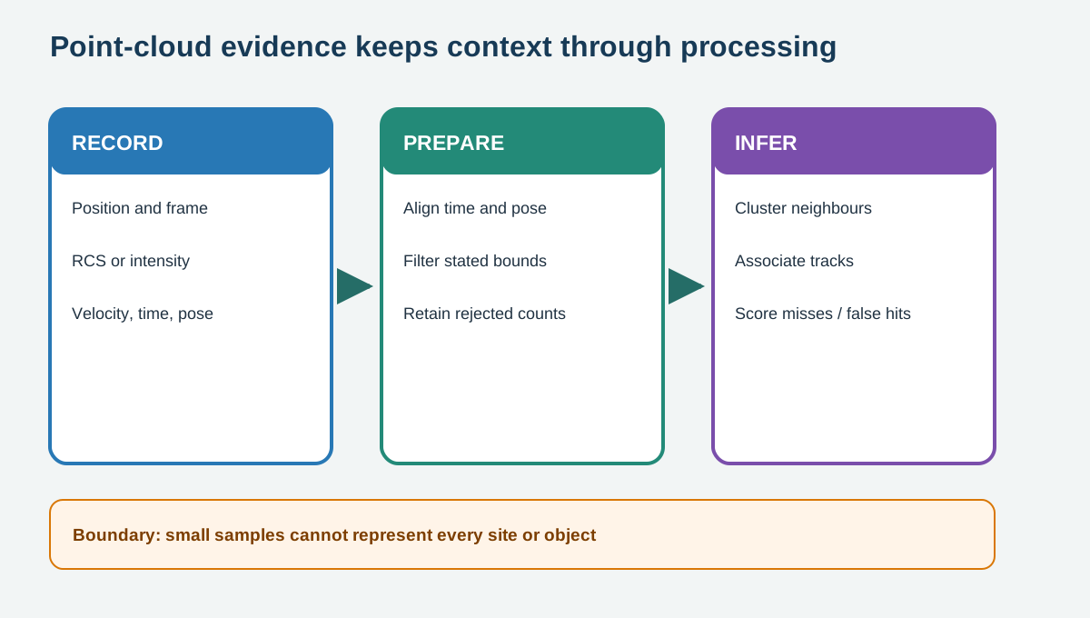
  • Remi must align the sensor pose, remove implausible points, group neighbours, and track a cluster without pretending every dot is an object.
Radar and lidar point-cloud processing chain from records through transforms, filters, clusters, and tracks.
iotclass.org

Major section

Overview

A point cloud is a set of detections in a coordinate frame.

  • Lidar points commonly carry 3D position, intensity, and time.
  • Radar detections may carry range, azimuth, Cartesian position, RCS, radial velocity, sensor identity, and time.
  • Filtering removes only points that fail stated rules; clustering proposes objects; tracking links proposals over time with uncertainty.
Radar and lidar point-cloud processing chain from records through transforms, filters, clusters, and tracks.
iotclass.org

Major section

Represent every point with context

Coordinates are meaningless without a frame and unit.

  • Sensor-frame points move with the device; world-frame points require a pose transform.
  • RCS and intensity are sensor-dependent return measures, not universal material labels.
  • Radial velocity measures motion along the radar line of sight, not full object speed.

Why it matters

Timestamps matter because the platform and targets can move during collection.

Radar and lidar point-cloud processing chain from records through transforms, filters, clusters, and tracks.
iotclass.org

Major section

Filter and cluster sparse returns

A range gate removes detections outside the application envelope.

  • Quality or RCS thresholds can suppress noise but may also remove weak people or surfaces.
  • Radar usually needs different thresholds from dense lidar.
  • Tune on training scenes, then preserve a held-out scene so the result is not judged on the same points that set the rules.
Radar and lidar point-cloud processing chain from records through transforms, filters, clusters, and tracks.
iotclass.org

Major section

Dataset and synthetic boundaries

The lab includes a small derived sample from RadarScenes sequence 158.

  • RadarScenes is licensed CC BY-NC-SA 4.0 and supplies automotive radar detections with point-wise labels and track IDs.
  • Both files are for teaching the pipeline; neither validates a product or a new environment.

Why it matters

The lidar room scan is synthetic because no compatible small public scan was selected for this wave.

Radar and lidar point-cloud processing chain from records through transforms, filters, clusters, and tracks.
iotclass.org

Major section

Summary

The useful output is an auditable chain from timestamped sensor records to scored associations.

  • That chain shows whether an apparent improvement came from better sensing, a tuned threshold, or a scoring rule that hid difficult cases.
  • A point is useful only with its frame, unit, time, sensor, and quality fields.
  • Filtering, clustering, and tracking introduce thresholds whose errors must be scored.
Radar and lidar point-cloud processing chain from records through transforms, filters, clusters, and tracks.
iotclass.org

Deck summary

Key takeaways

Radio Remi sees two maps of the same loading area.

  • A point cloud is a set of detections in a coordinate frame.
  • Coordinates are meaningless without a frame and unit.
  • A range gate removes detections outside the application envelope.
  • The lab includes a small derived sample from RadarScenes sequence 158.
iotclass.org

Retrieval practice

Recall check

Radio Remi says: answer from memory, then check your reasoning.

Q1What must accompany point coordinates before sensors can be compared?

AA named frame, units, time, and sensor pose
BOnly a brighter colour
CA camera identity for every dot
DA guarantee that each point is an object
Show answer

Answer: A A named frame, units, time, and sensor pose.

Q2Why tune clustering on training scenes and score a held-out scene?

ATo expose whether the chosen thresholds transfer beyond the tuning points
BTo make radial velocity equal full speed
CTo remove every false return
DTo change the dataset licence
Show answer

Answer: A To expose whether the chosen thresholds transfer beyond the tuning points.

iotclass.org

Print reference

Answers

Answer key.

  1. A · A named frame, units, time, and sensor pose.
  2. A · To expose whether the chosen thresholds transfer beyond the tuning points.
iotclass.org